Project Category: Civil
JOIN OUR PRESENTATION
Join us in our ZOOM Room on April 5, 2022, to learn more.
For any issues and concerns accessing this room, please contact ian.roman@ucalgary.ca
ABOUT OUR PROJECT
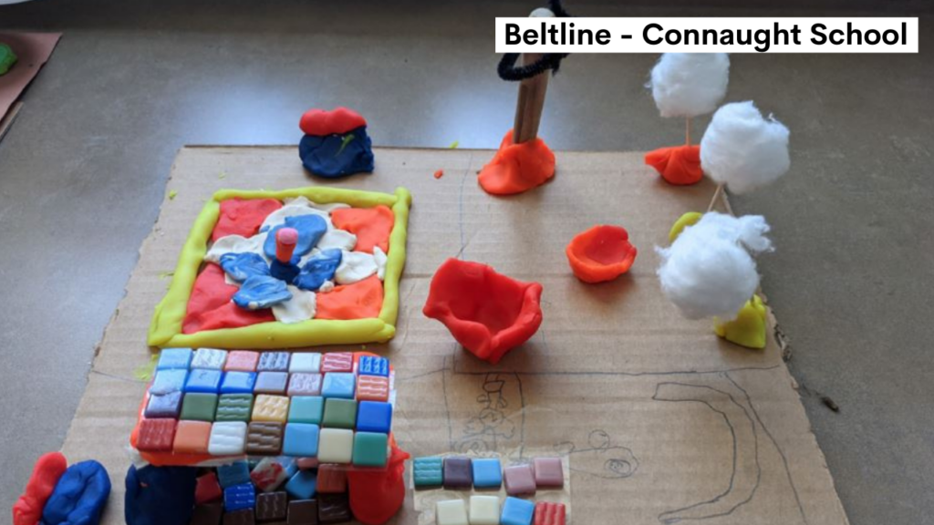
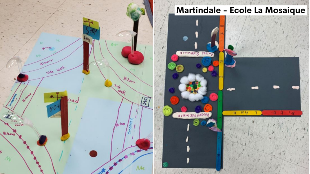
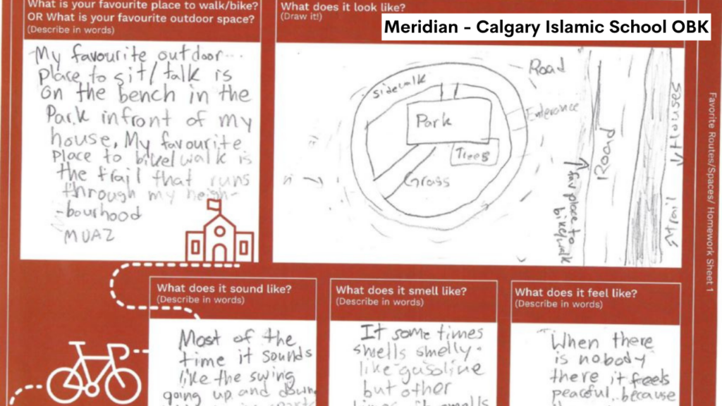
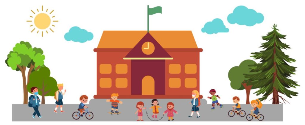
Background: Stepping Towards a Greener Tomorrow (STGT) is a partnership project1,2 with Ever Active Schools, Sustainable Calgary, and the City of Calgary with the aim of supporting schools and communities to promote active travel modes to kids. This project is the basis for this capstone, Active Transportation Safety for School Access, where students from each school were involved in planning and designing their idea of a healthy and walkable community. Incorporating the perspective of children and prioritizing them as users is a collaborative approach in hopes of better promoting active modes of travel. The kids were asked to communicate their ideas through sketches and other artistic representations, as well as data collection, in the form of surveys. This information served as the foundation of the detailed design process.
Schools that have participated in the past received infrastructure changes such as improved signage, upgraded crosswalks, and improved cycling facilities. Currently, the STGT initiative is in progress for four schools within the City namely École La Mosaïque (Martindale), Calgary Islamic School OBK (Meridian), Connaught School (Beltline), and Manmeet Singh Bullar School (Martindale). The first three schools mentioned were currently the focus of this capstone project where detailed design was undertaken to bring the student’s ideas closer to the implementation phase.
Project Objective: The aim of this capstone project was:
- to design future street improvements for each school to promote active modes of travel and to facilitate a safer environment for all road users;
- to plan for the future active transportation network for the communities where each of the schools were located and;
- to estimate CO2 emissions before and after the street improvement is implemented.
WHAT IS ACTIVE TRANSPORTATION?
According to the Government of Canada4,5, active transportation describes all human-powered forms of travel, such as walking, cycling, skateboarding, skiing, canoeing, and more. Public transit can also be considered a form of active transportation since it involves at least one active mode mentioned above to start and finish a trip. Active transportation has many benefits such as improving air quality, reducing greenhouse gas emissions, increasing opportunities for physical activity, decreasing road congestion, and saving money.
MEET OUR TEAM MEMBERS


DETAILS ABOUT OUR DESIGN
Street / Road Design
Our team utilized various design and policy documents to aid in the design development process. Design standards such as the Design Guidelines for Subdivision Servicing (City of Calgary, 2020) and NACTO Designing Streets for Kids and City of Calgary policies such as Traffic Calming (2010) and Pedestrian Strategy Report (2016) were reviewed to ensure that the design options developed for each school follow the standard for designing future street interventions while achieving the goals of this project.
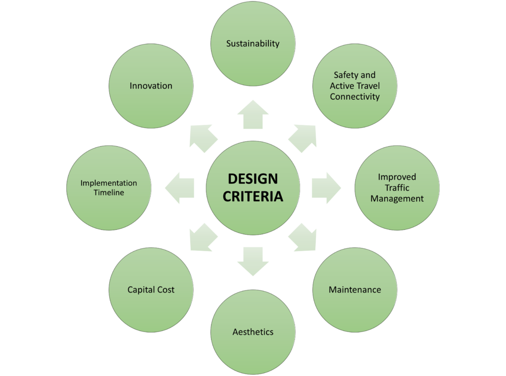
Upon reviewing these design standards and policies, design options were developed for each school making sure it follows the current street design standards while incorporating the kid’s insights to achieve an active and walkable community. A set of design criteria was also developed to select the optimal design that will effectively and efficiently address the existing challenges of each school.
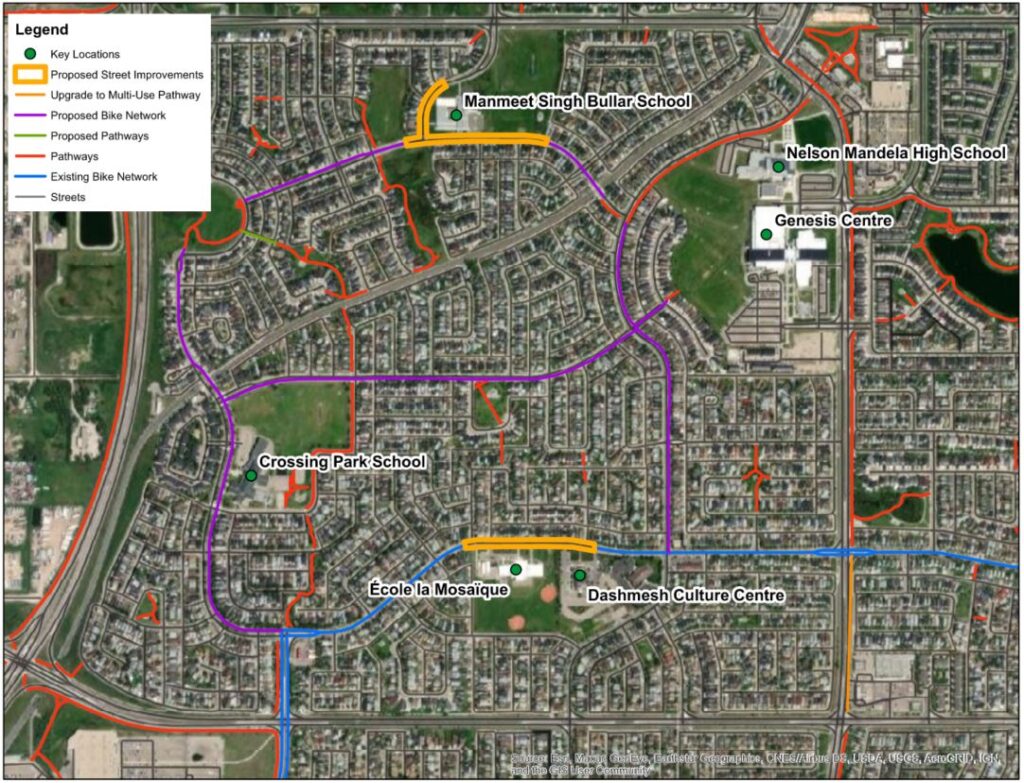
Neighborhood Active Transportation Network (NATN) Plan
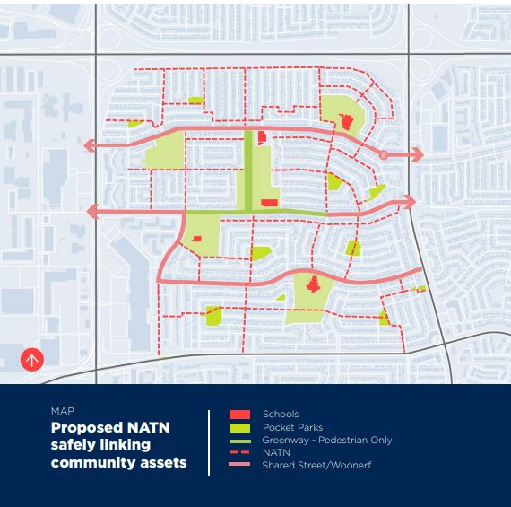
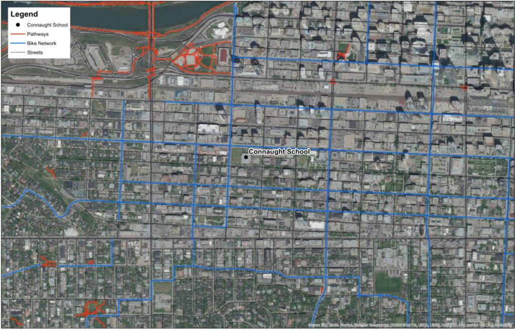
Aside from the proposed street improvements, part of our capstone project involved developing a neighborhood active transportation network (NATN) plan for each of the communities investigated. According to Sustainable Calgary6, a NATN is a network map of infrastructure that supports active modes of travel. This network is intended to effectively and safely connect key locations within the community. At the community level, the proper implementation of a NATN plan will further encourage active modes.
A NATN is additionally useful in determining any gaps or deficiencies in the existing active transportation system. This will facilitate the necessary infrastructure to provide a complete and functional network. In planning for the NATN, the Complete Streets Guide for both the City of Calgary and Edmonton7,8 was reviewed to ensure all the existing deficiencies and challenges were addressed appropriately. Both guides agree that to attain a “Complete Street”, the following principles must be incorporated during the planning process:
- all networks of transportation infrastructure (i.e., transit, streets, active) must be coordinated to accommodate all users and ensure a high-quality travel experience,
- street networks must promote sustainability through utilizing the local natural features and ecosystem, along with a healthy balance between economic and social factors,
- transportation networks must provide multiple safe travel options for all ages and must be operational in varying conditions,
- promote a vibrant and livable realm where interaction is encouraged to promote a higher quality of life.
A rigorous investigation was performed of the existing conditions. This utilized several methods, such as site visits, Google Earth inspections, and the current City of Calgary active transportation infrastructure GIS data9. With a combination of knowledge gained from these studies, an updated NATN plan for each community was created.
Beltline – Connaught School
Proposed Design
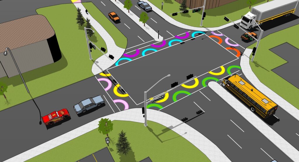
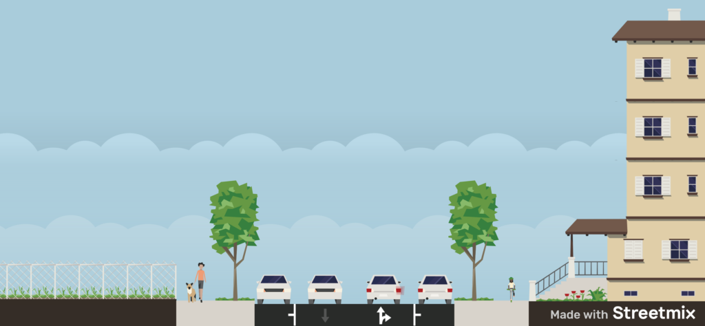
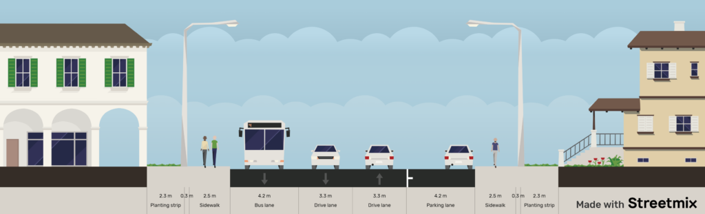
The Connaught School in the Beltline neighborhood of downtown Calgary comes with unique challenges due to its central location. One of these challenges is the safety and aesthetics of the surrounding area, therefore the final design provides an innovative solution to address these problems. To provide safety for the school commuters our selected design involved relocating the school zone signs. The current signage in the area provides little to no forewarning. Relocating the signs farther away from the school will provide incoming traffic with more time to slow down to the appropriate speed.
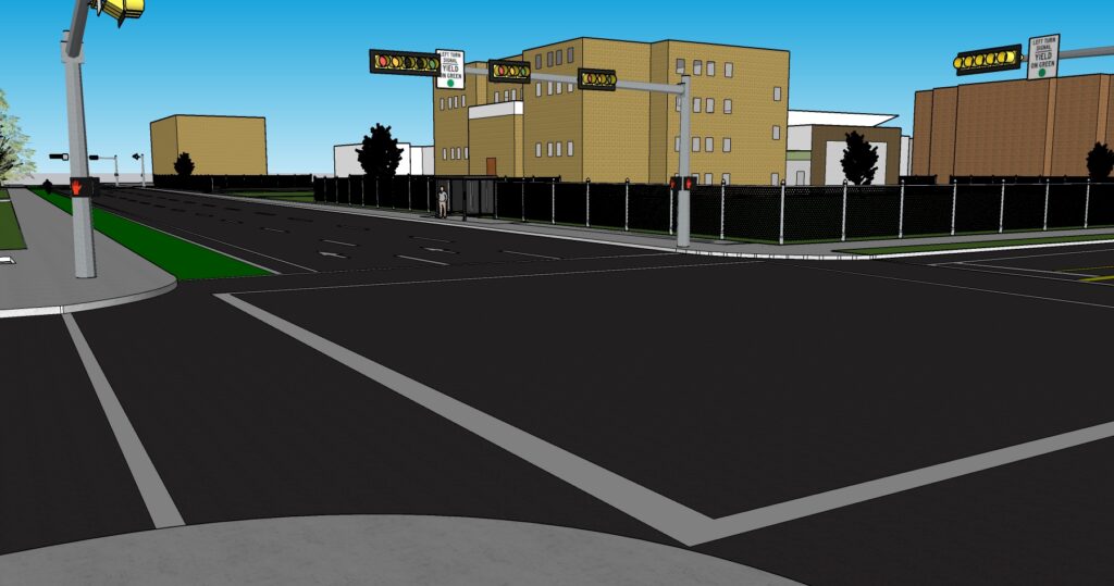
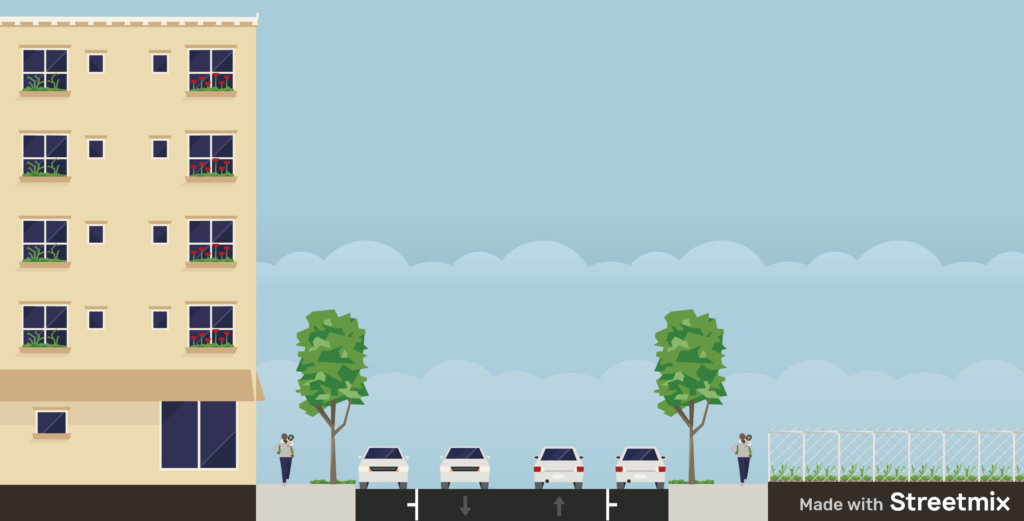
Currently, the 11th Street and 12th Avenue intersections do not provide adequate time for children to safely cross 12th Avenue at a normal walking pace. Therefore, our design suggests the lengthening of the northbound and southbound signals to increase the amount of time allocated for those crossing the street. The Complete Streets Design and Construction Standards published by the City of Edmonton8 recommend that sidewalks have a minimum 2.5-meter width. Our design incorporates the widening of the concrete monowalks and separate walks around the school to provide a more comfortable walking space.
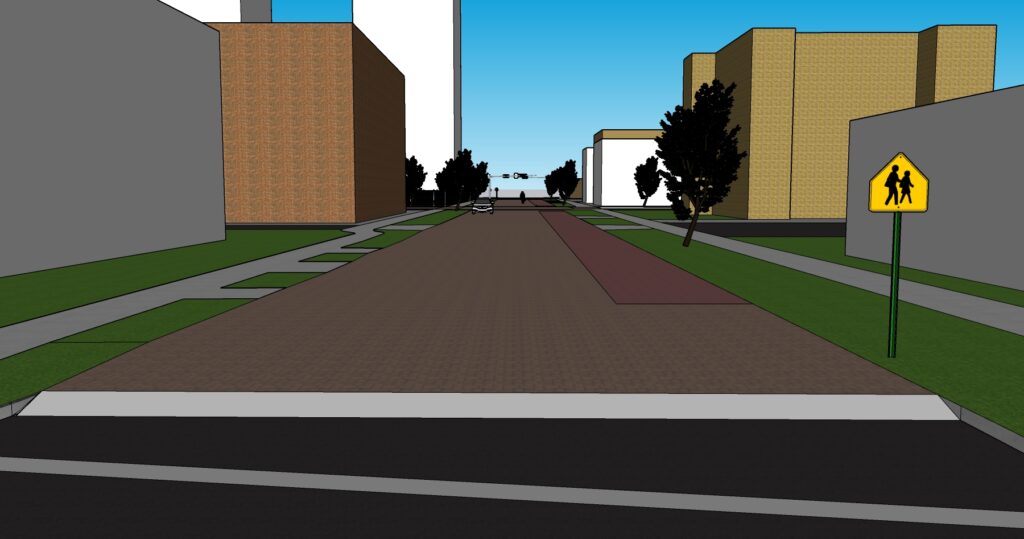
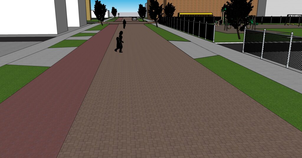
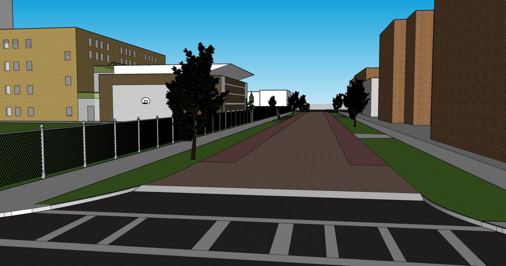
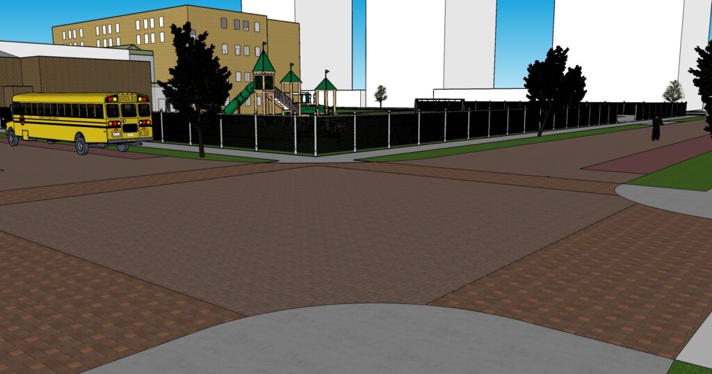
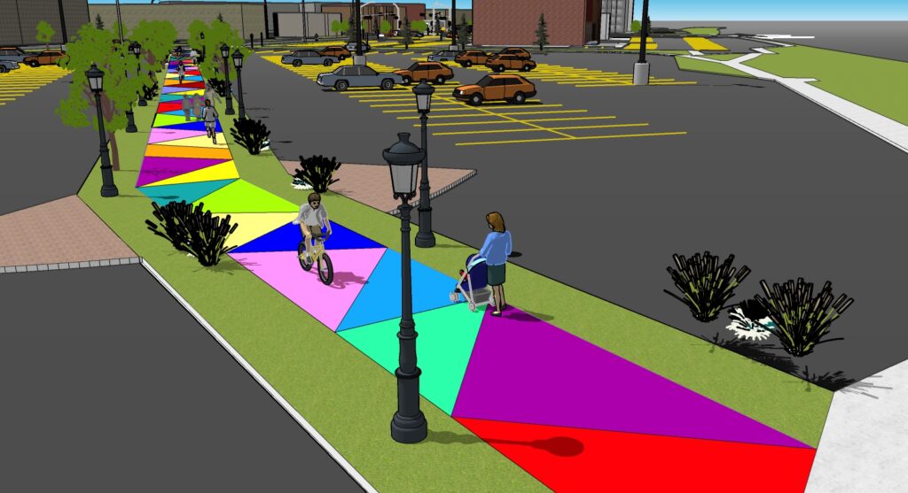
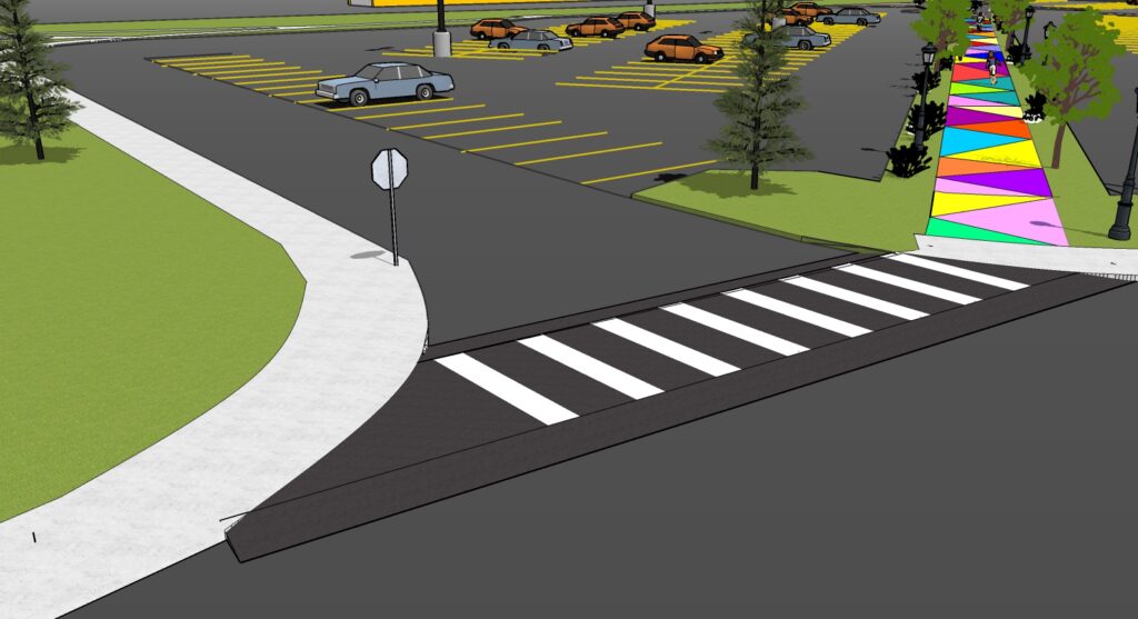
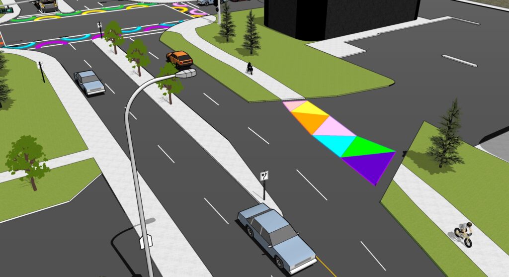
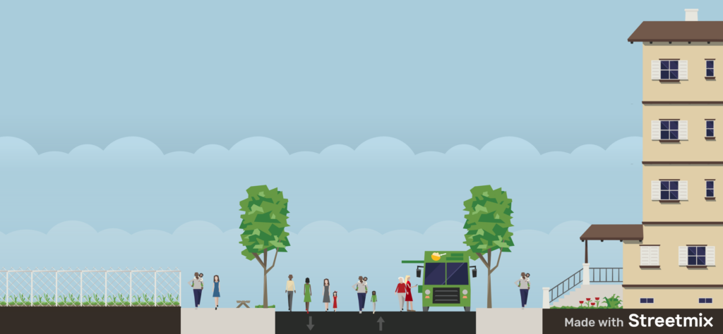
To further promote active transportation in the area, the implementation of a shared street between 10th Street and 13th Avenue would be effective. The current roads would be repurposed to have pavers level with the sidewalks to create a unique area, causing drivers to be more attentive. The shared street would lower the speed limit to 15 kilometers per hour, discouraging unnecessary automobile traffic due to the many streets available in downtown Calgary. The design would also create an atmosphere encouraging foot traffic due to the scenery it brings, as well as freedom for pedestrians. Overall, this design is an innovative solution being the only shared street in Calgary that allows automobile traffic alongside active modes of transportation.
Connaught School Shared Street Concept (Click to view full animation)
Proposed 10th Street Northbound
Proposed 10th Street Southbound
11 Street / 12 Avenue
Proposed 13th Avenue Eastbound
Shared Street Crosswalks
Proposed Neighborhood Active Transportation Network (NATN)
The table below summarizes the proposed activities for potential infrastructure upgrades and street redesign to maintain the existing active transportation network:
| Activity | Proposed Action |
|---|---|
| Widen Existing Sidewalks | The survey data provided revealed that people have concerns about walking and crossing around the Beltline area. Reviewing the GIS data for the Beltline Community, some of the sidewalks around the neighbourhood need to be widened to reduce pedestrian crossing distances and increase space for pedestrians. Sidewalk extensions will narrow the roadway while increasing the available waiting space. For example, the sidewalk along 8th Street SW should be widened to promote walking to the school and around the community. |
| Upgrade Streets into Mixed-use Streets | As Beltline is a densely populated neighbourhoods of the city, upgrading streets to mixed-use streets will ensure a pedestrian-priority street. The road should be designed for slow travel speeds where those walking, cycling, and driving all share the right of way. Similar to the proposed shared street design, the street from the nearby C-Train station to Beltline Connaught School should be upgraded. Shared streets can be designed and managed in a variety of different ways to balance the needs of all users while enhancing the safety, aesthetics, and overall experience of the street. |
| Crosswalk Improvements | Data review shows that there are many intersections that are very difficult to cross around the community. To improve crosswalks and pedestrian safety, crosswalks should be upgraded with reflective crosswalk signs, flashing lights, and protected intersections, with warrant review, to make them more visible to drivers. By doing so, drivers will have more time to reach the crosswalk traffic even in dangerous driving conditions. The proposed upgrade should also be designed to accommodate visually impaired pedestrians from veering out of the crosswalk’s safety. |
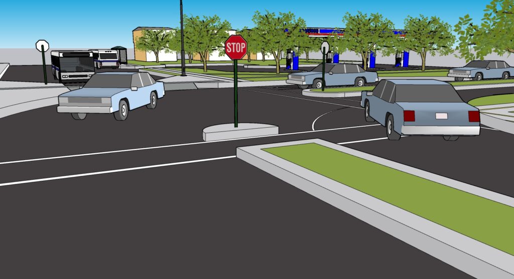
Martindale – École La Mosaïque
Proposed Design
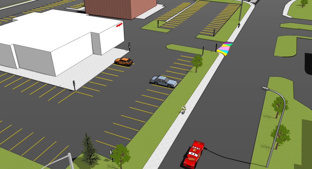
École La Mosaïque is one of the four elementary French immersion schools in Calgary located in the northeast (NE) part of the City in the community of Martindale. Most students that go to École La Mosaïque use school buses or get driven by their parents/guardians. As such, the primary goals for our design are to increase the safety of students taking buses and make alternate transport options more appealing for those who get picked up or dropped off.
Our design is separated into two major areas of proposed changes to the transportation area:
Mid-Block Barrier Design (Click to view full animation)
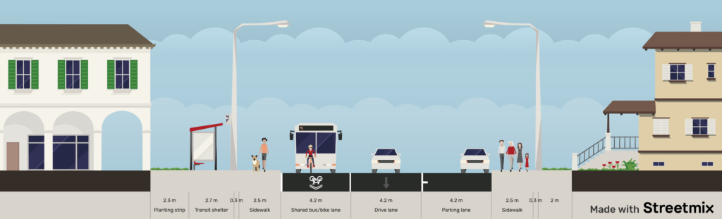
Adding a mid-block barrier on Martindale Blvd. just north of École La Mosaïque school and a bi-directional bike lane with plastic bollards in the south parking lane of Martindale Boulevard. The mid-block barrier design is to force drivers to use other routes as most of the traffic on Martindale Boulevard is through traffic. The major change is the addition of two opposing cul-de-sacs to make vehicles turn around the way they came. It also allows only buses and fire trucks to cross to encourage using active or public transportation and for drivers to use 64th Avenue instead, which is the main collector road located south of Martindale Boulevard.
The addition of a bi-directional bike lane and plastic bollard barrier is meant for cyclists traveling through the south parking lane to feel safer which could ultimately increase the number of people using active transportation. We suggest the remaining north parking lane be ‘permit only’ to ensure residents around the area have enough parking. By doing so, this may force parents/guardians to park farther away, hence encouraging other modes of transport and reducing emissions directly near the school.
MidBlock Barrier Design
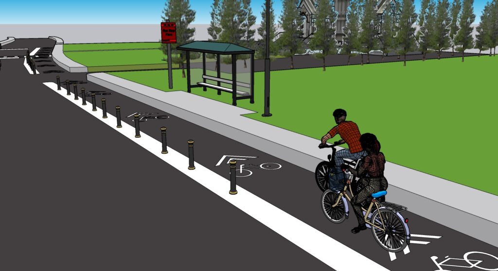
Bi-directional Bike Lanes along Martindale Boulevard
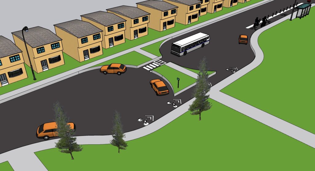
Martindale Gate / Martindale Boulevard Diversion Plan (Click to view full animation)
The intersection of Martindale Gate and Martindale Boulevard will be altered to divert traffic from going through the east of Martindale Boulevard. Our design contains a concrete surface raised to the grade of the sidewalk on the entrance onto eastbound Martindale Boulevard. This makes the turn from westbound Martindale Blvd. to Martindale Gate easier and decreases driver confusion.
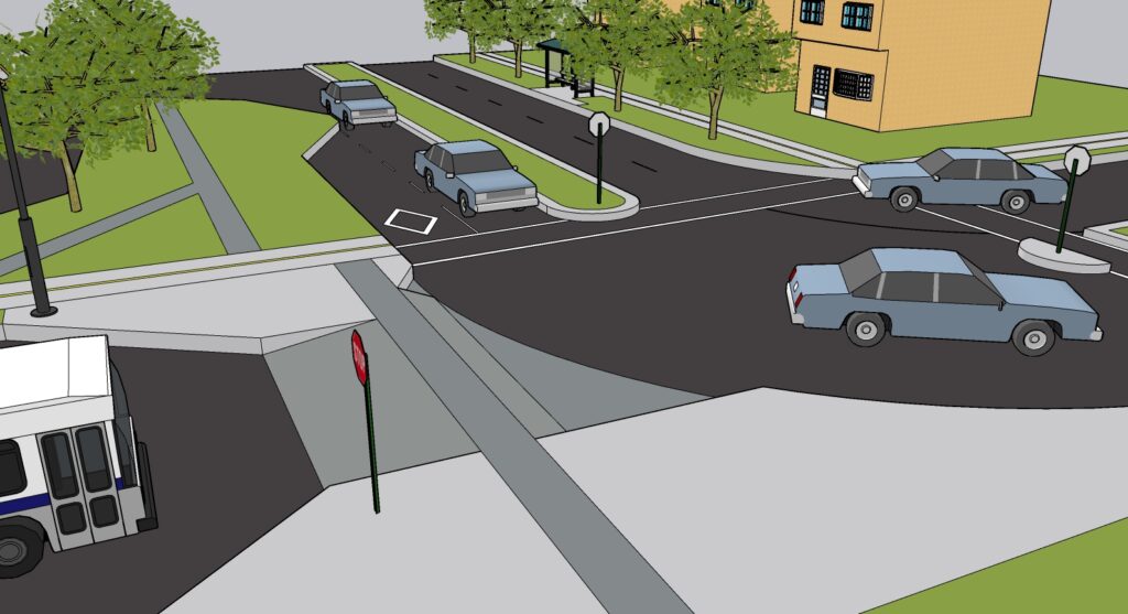
Elevated Driveway-style entrance to Martindale Boulevard EB
Proposed Neighborhood Active Transportation Network (NATN)
Upon reviewing the available GIS data for the community of Martindale, the existing active transportation network was reviewed for discontinuities, potential infrastructure upgrades, and/or provision of a street redesign. The table below summarizes the proposed activities to maintain the existing active transportation network:
| Activity | Proposed Action |
|---|---|
| Manmeet Singh Bullar School Street Redesign | Manmeet Sing Bullar (MSB) School was also a part of the STGT along with the schools under this project. Upon reviewing the survey data of this school, it shares the same issues/challenges as École La Mosaïque. A street redesign similar to the ones undertaken for École La Mosaïque will be needed. A combination of traffic calming measures (vertical/horizontal deflections) will be implemented to address the existing challenges and to make active travel modes safer for kids. |
| Upgrade some existing sidewalks to multi-use pathways | To provide a shared alignment for both walkers and bikers, existing sidewalks from Martindale Gate / Martindale Boulevard to Martindale LRT Station must be upgraded to multi-use pathways to provide continuity in the existing bike network in the community. The sidewalk along Falconridge Boulevard from 64 Avenue to Tararidge Circle must also be upgraded to a multi-use pathway to connect to the existing multi-use pathway along the boulevard. |
| Martindale Bike Network | Reviewing the GIS data, infrastructure for walking was complete for this community but cycling infrastructure is lacking. The proposed bike network will go around Martindale Boulevard and a connection between Martin Crossing Drive and Martindale Drive. This network ensures the bike network continuity with the existing network in the community. Given that this network is provided, it connects biker paths not just from Martindale but also to neighboring communities such as Taradale and Castleridge. |
Meridian – Calgary Islamic School OBK
Proposed Design
Considering OBK is primarily a commuter school, located in an industrial area of Calgary, our design focuses on connecting students to public transit. The final design for Meridian provides a safe path from the Franklin LRT Station to OBK.
Calgary Islamic School OBK (Click to view full animation)
Our design can be separated into three major areas of proposed changes to the transportation area:
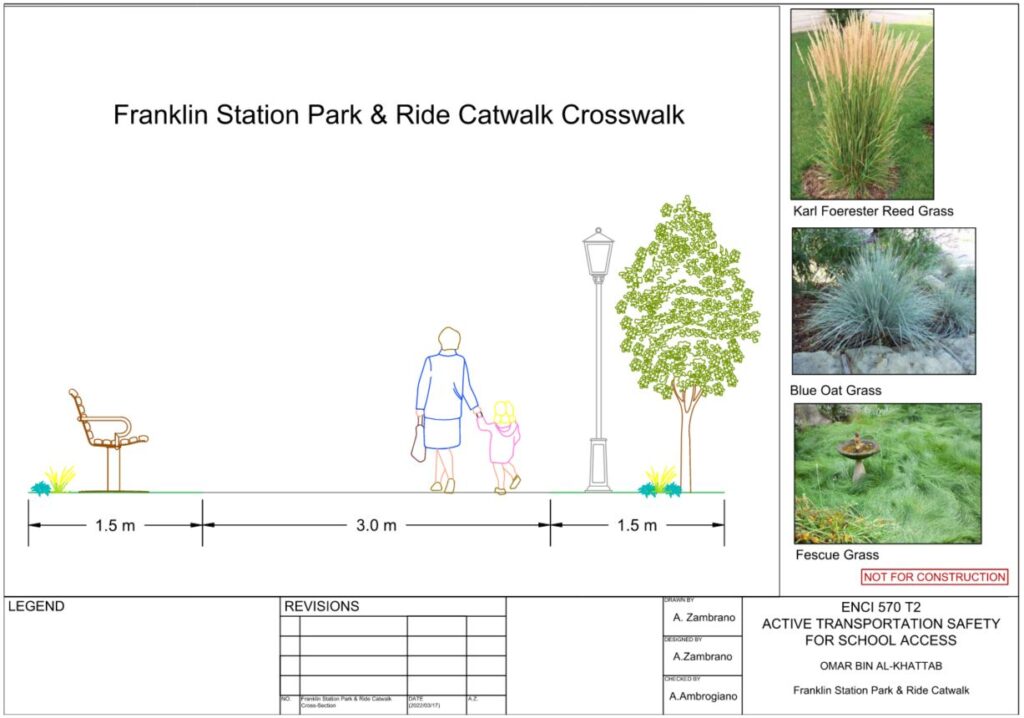
Franklin Station Park & Ride Proposed Walkway
The diagonal walkway serves as a direct path towards 28th Street from the Franklin Station bridge that crosses Memorial Drive. This would be constructed as a 3.0-meter-wide painted asphalt pathway, with a 1.5-meter greenspace running adjacent to both sides. A raised crosswalk would be implemented across the East entrance of the Park & Ride lot. We consciously proposed continuous sidewalks from the LRT Station to improve the visibility of small children.
Franklin LRT Park & Ride Diagonal Walkway
Raised Crosswalk Connection
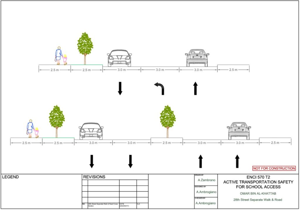
28th Street SE Redesign
To allocate adequate space for a separate walk leading to the school, the alignment of 28th Street was adjusted. This involved the narrowing of lanes and median, along with designating a specific lane for left turns into the north entrance of the school.
28th Street Improvements – Mural Crosswalks
28 Street Improvements – New Median and Sidewalk
OBK Parking Lot Alterations
Our design proposes that the south entrance be resurfaced to green space to provide a greater area to stay and play as well as improve permeability. We have suggested the south section of the lot to prevent vehicle use unless necessary for specific events. Finally, to reduce the direct emissions and traffic near OBK, our design suggests the utilization of shared space. The north parking lots of the restaurants south of the school would be allocated as a pick-up and drop-off zone for certain times of the day.
Proposed South Greenspace
Proposed Neighborhood Active Transportation Network (NATN)
The current road network in Meridian does not have a pathway linking all the bus stops in the area. The green line in our proposed NATN shows a path that our group has proposed for construction in the future. This is intended to achieve better connectivity of all the bus stops in the area, promoting people to walk and take transit.
Our proposed NATN also includes the entities from the final design for OBK. This includes the diagonal pathway in the parking lot, connecting to the sidewalk on 2nd Ave. As well as the separate walk on the southbound side of 28th Street. This pathway leads to the south entrance of OBK school from the Franklin station providing greater connectivity to the school from public transit.

Emissions Modeling
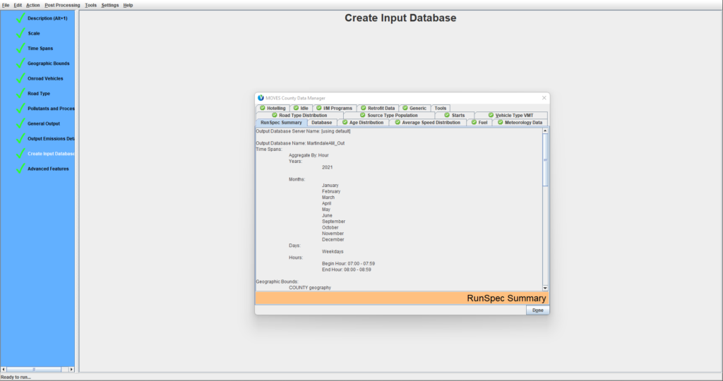
In order to validate the designs, CO2 emissions were estimated using the Motor Vehicle Emission Simulator (MOVES) software by US Environmental Protection Agency. MOVES is an emission modeling system with the capability of estimating air quality by measuring air pollutants, greenhouse, and toxic gas emissions. MOVES measures on-road traffic such as passenger cars, trucks, and buses and non-road vehicle emissions as well. MOVES accepts input such as vehicle information, fuel consumption, temperature, and humidity in measuring emissions for a specific project area10.
Model Input
Certain parameters are needed for a functional emissions model. The table below summarizes the type of input that MOVES Onroad needed. For the purpose of presentation, the data used in the table was for estimating the emissions for vehicles traveling to and from the École La Mosaïque area in the community of Martindale.
| Parameter | Definition | Existing Condition Scenario Value(s) / Range(s) | Future Condition Scenario Value(s) / Range(s) |
|---|---|---|---|
| Vehicle Miles Travelled | Total distance traveled by all vehicles from the community within the catchment of the school11 | Cars: 342.24 miles Buses: 74.56 miles | Cars: 186.05 to 330.26 miles Buses: 40.06 to 72.1 miles |
| Road Type Distribution | Road classification of which vehicles travel to and from the school | local roads, collector roads, arterials | local roads, collector roads, arterials |
| Speed Distribution | Average speed bins of vehicles that travel to and from the school | Speed Bin 6-13 (22.5 mph to 62.5 mph) | Speed Bin 6-13 (22.5 mph to 62.5 mph) |
| Source Type Population | Type of vehicles that travels to and from the school | 74 cars and 6 buses | 40 to 70 cars; 4 to 6 buses |
| Age Distribution | Vehicle age of vehicles that travels to and from the school | new to 30 years (both vehicle types) | new to 30 years (both vehicle types) |
| Fuel Data | Specific fuel type for each vehicle type used for travel | Cars: gasoline Buses: diesel | Cars: gasoline Buses: diesel |
| Meteorology Data | Local temperature and humidity12,13 | Temperature: 16.7 F to 57.2 F Average Humidity: 48% to 70% | Temperature: 16.7 F to 57.2 F Average Humidity: 48% to 70% |
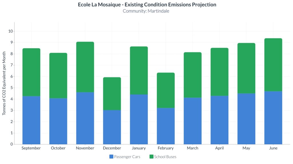
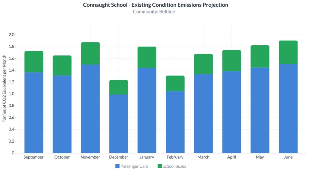
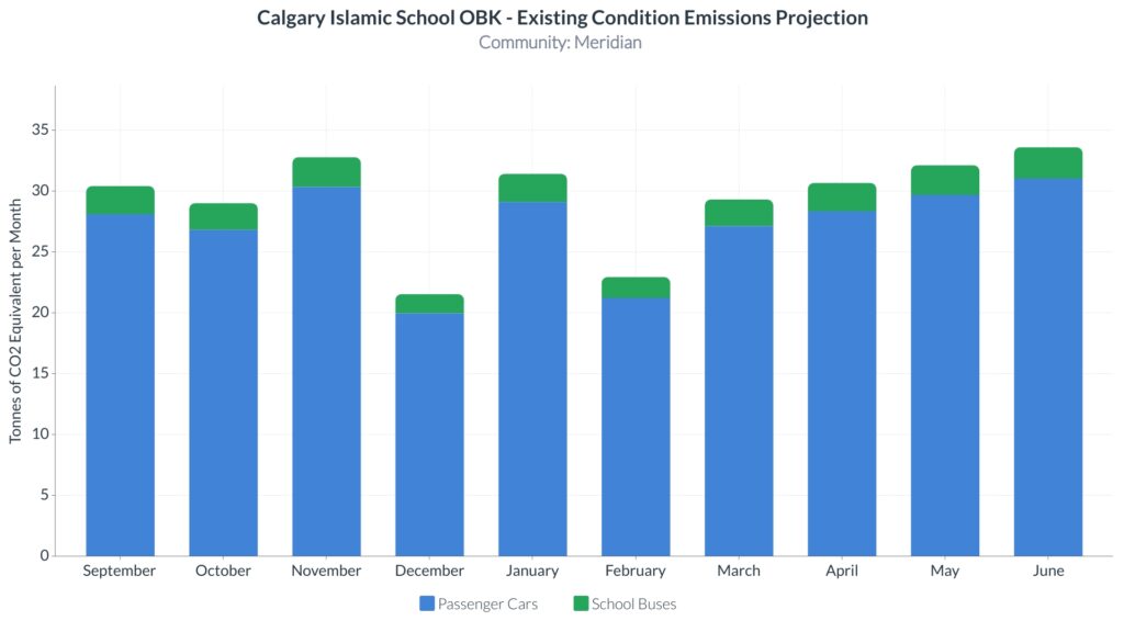
Results – Existing Condition Scenario
Using the parameters summarized in the Existing Condition Scenario column from Table 1, the estimated emissions result under the existing traffic condition for École La Mosaïque is shown below. The graph shows the amount of CO2 emissions for École La Mosaïque during the school year where the months that have the highest number of school days have the greatest emissions.
Results – Future Condition Scenario
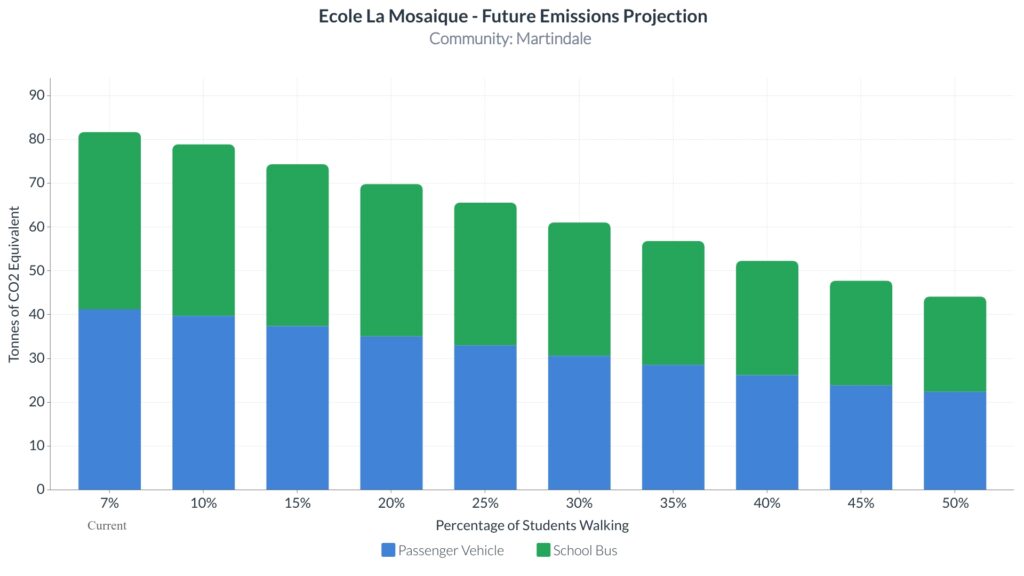
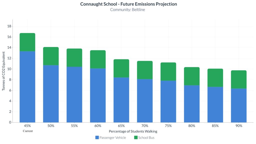
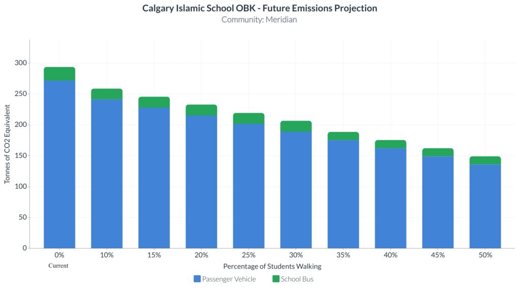
Lastly, given that the proposed street design will shift more to active travel modes, a future emissions scenario was also generated where parameters Vehicle Miles Travelled (i.e. distance traveled) and Source Type Population (i.e. vehicle type) were adjusted to reflect the shift of reducing vehicular means of travel. From the graph below, emissions will decrease as the number of students increasingly use an active mode of travel. Theoretically, if 50% or more of the student population travel by either walking and/or cycling, CO2 emissions equivalent to 87 barrels or more of oil would be saved14.
Preliminary Construction Costs
To assess the feasibility of each proposed design, preliminary construction cost estimates were developed. The cost estimate used the unit price method and the unit prices were derived from the Alberta Transportation (AT) Unit Price Averages Report15 which shows typical transportation/water resources construction activities and their associated unit prices. For items not included in the AT report such as plastic bollards, for example, our team researched for specific vendors that can provide such material and get the price from their brochures.
| Project Location | Preliminary Construction Cost Estimate |
|---|---|
| Beltline – Connaught School | $245,000 |
| Martindale – École La Mosaïque | $171,000 |
| Meridian – Calgary Islamic School OBK | $645,000 |
PARTNERS AND MENTORS
We want to thank the many people who helped us with this project. Our academic advisor Dr. Alex De Barros guided us through the process with patience and great advice. Additionally, our consultation with the following industry advisors was invaluable:
- Celia Lee, Executive Director, Sustainable Calgary
- Ryan Martinson, M.Eng., P.Eng., RSP, Senior Engineer / Sustainable Transportation Specialist, Toole Design


OUR PHOTO GALLERY
Engineering Design Drawings
Beltline – Connaught School
Martindale – École La Mosaïque
Meridian – Calgary Islamic School OBK
Street Cross Sections
Calgary Islamic School OBK – Franklin Station Park and Ride Crosswalk Cross Section
Calgary Islamic School OBK – Proposed 28th Street Cross Section
Emissions Modeling Results
REFERENCES
- C. Lee, “Stepping towards a Greener Tomorrow,” Sustainable Calgary, 10-Sep-2021. [Online]. Available: http://www.sustainablecalgary.org/projects/2021/8/23/stepping-towards-a-greener-tomorrow. [Accessed: 26-Mar-2022].
- Ever Active Schools, “Ever active schools,” Ever Active Schools. [Online]. Available: https://everactive.org/projects/ast/stepping-toward-a-greener-tomorrow/#:~:text=Stepping%20Toward%20a%20Greener%20Tomorrow%20aims%20to%20support%20school%20communities,the%20School%20Travel%20Planning%20process. [Accessed: 26-Mar-2022].
- Sustainable Calgary and Ever Active School, “Parent / Student Survey Data – Stepping Towards a Greater Tomorrow.” Various, Calgary, 2021.
- Public Health Agency of Canada, “Government of Canada,” Canada.ca, 02-May-2014. [Online]. Available: https://www.canada.ca/en/public-health/services/being-active/active-transportation.html. [Accessed: 26-Mar-2022].
- “Share your input! active transportation plan survey,” City of Trail, 24-Jan-2022. [Online]. Available: https://trail.ca/en/news/share-your-input-active-transportation-plan-survey.aspx. [Accessed: 26-Mar-2022].
- C. Lee, “Neighbourhood Active Transportation Networks Policy,” Sustainable Calgary, 09-Nov-2021. [Online]. Available: http://www.sustainablecalgary.org/publications-1/2020/11/18/neighbourhood-active-transportation-networks. [Accessed: 30-Mar-2022].
- Complete Streets Guide – The City of Calgary, City of Calgary, Calgary, Alberta, Canada, 2014, Accessed: 30-Mar-2022. Available: https://www.calgary.ca/transportation/tp/planning/calgary-transportation-plan/complete-streets.html
- Complete Streets Design and Construction Standards, Version 04, City of Edmonton, Edmonton, Alberta, Canada, October 2021, Accessed: 30-Mar-2022. Available: https://www.edmonton.ca/public-files/assets/document?path=PDF/CompleteStreets_DesignStandards_2021.pdf
- City of Calgary, Open Calgary. [Online]. Available: https://data.calgary.ca/. [Accessed: 30-Mar-2022].
- US Environmental Protection Agency, “MOVES and Other Mobile Source Emissions Models,” EPA. [Online]. Available: https://www.epa.gov/moves/latest-version-motor-vehicle-emission-simulator-moves. [Accessed: 30-Mar-2022].
- “Transport scolaire,” FrancoSud, 06-Jan-2022. [Online]. Available: https://francosud.ca/accueil/programme-et-services/transport-scolaire/. [Accessed: 30-Mar-2022].
- “Relative humidity – monthly data for Calgary,” Amateur Weather Statistics for Calgary, Alberta. [Online]. Available: https://calgary.weatherstats.ca/charts/relative_humidity-monthly.html. [Accessed: 30-Mar-2022].
- “National Centers for Environmental Information,” National Centers for Environmental Information (NCEI). [Online]. Available: https://www.ncei.noaa.gov/. [Accessed: 30-Mar-2022].
- “Greenhouse Gas Equivalencies Calculator,” EPA. [Online]. Available: https://www.epa.gov/energy/greenhouse-gas-equivalencies-calculator. [Accessed: 02-Apr-2022].
- Alberta Transportation, “Unit prices and cost adjustments,” Alberta.ca. [Online]. Available: https://www.alberta.ca/unit-prices-and-cost-adjustments.aspx. [Accessed: 02-Apr-2022].
