Project Category: Civil
Join our presentation
The Problem
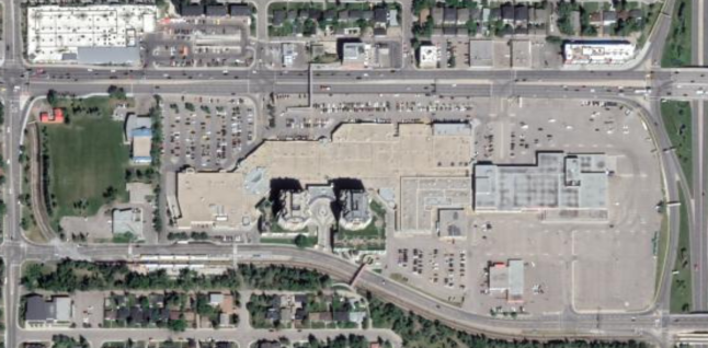
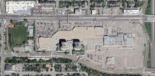
Over the past several years, Calgary has seen a rise in the number of major storm events classified as 1 in 100 year or greater storms. Thus, the practical issue the city is interested in is redeveloping areas that are already at risk of flooding which may get worse with further densification and climate change. We chose an existing community that is an example of such concerns; in addition, the community has little to no improvement of the quality of the stormwater either. An innovative approach used in other jurisdictions is the multi-purpose use of any available space within a community including shopping malls. Our team was commissioned to investigate such approach in a Calgary context and create a water sensitive approach to redeveloping an existing mall with a design that can address these concerns.
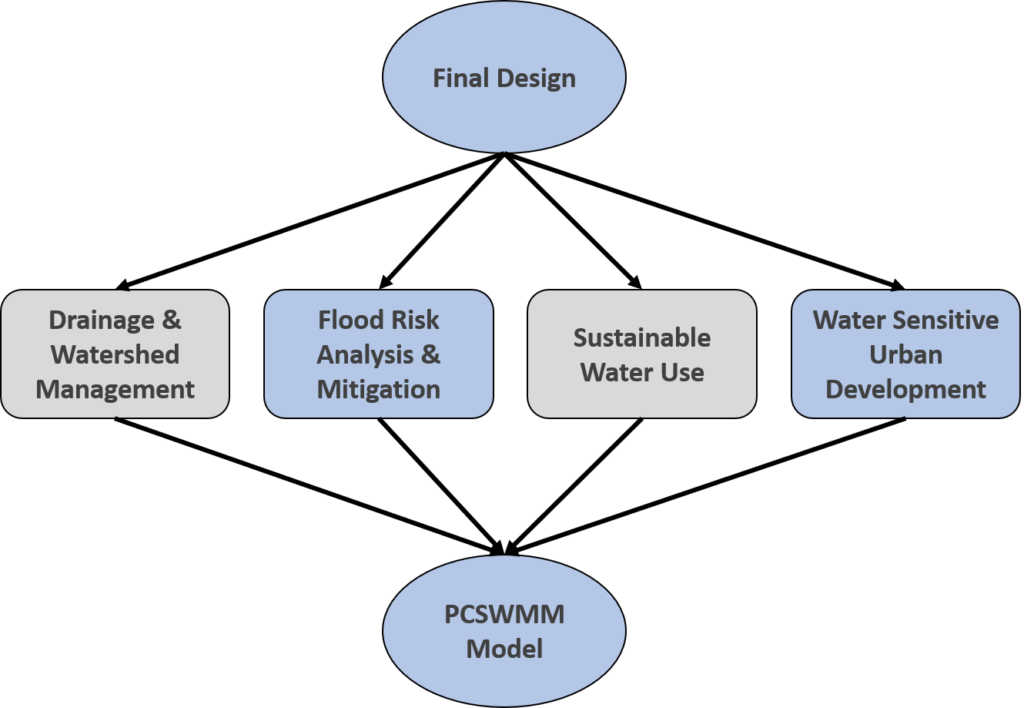
As this project focuses on environmental sustainability, innovation was strongly encouraged by advisors to redevelop the site with the following concepts in mind: sustainable water use, drainage and watershed management, flood risk analysis and mitigation, and water sensitive urban development.
In addition, our advisors challenged the team to focus on water-oriented development which prioritizes the potential flow of water through the site and the protection of the natural water cycle, whereas the current site is mainly impermeable and does not take into account stormwater management. With this in the forefront, the team was then advised to arrange the buildings, open spaces, and roads to better facilitate the movement, storage, and treatment of stormwater on the site. This water-focused approach is relatively new and is the main aspect that differentiates this project from the standard urban planning approaches of the past.
This project was done for educational purposes and focused largely on the water management aspects. As such, it is not an accurate representation of any changes being made in Calgary.
Glossary of Terms
- 1:100 Year Storm Event: A major storm event that occurs once every 100 years, and most susceptible to flood risk.
- I/P Ratio – The ratio of impermeable to permeable surface area. As I/P ratio increases, less stormwater is absorbed – increasing the risk of flooding.
- Run-off – Another term for excess stormwater that is yet to be absorbed or stored.
- Minor System – The minor stormwater drainage system comprises of roof gutters, rainwater leaders, swales, street gutters, storm sewers and underground pipe systems. It is designed to accommodate runoff from frequent storms (1-5-year storms) and minimize localized flooding.
- Major System – A major stormwater drainage system includes natural streams, man-made streets, swales, channels and ponds. It is designed to accommodate runoff from major storm events that occur less frequently (100-year storm).
- Peak Flow Reduction – Reducing peak flow rates of stormwater to reduce the risk of overwhelming sewer systems to prevent surcharge and flooding.
- Volume Reduction – Reducing the volume of runoff to protect rivers and drinking water sources from runoff contamination, to reduce the amount of sediment and nutrients that reaches, and to prevent erosion.
- Flood Zone North of Site – The main focus area of the stormwater management design in our site. All stormwater designs will mitigate floods from the flood zone north of the site.
- Unit Area Release Rate (UARR) – The maximum flowrate that is permitted to leave the site – UARR = 16L/s/ha, according to our industry advisor.
Innovative Design Interventions
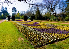
Absorbent Landscaping
Landscapes of various sizes and vegetation that can absorb stormwater and reduce run-off volumes. Examples include grass, fields, parks, and rain gardens.
Stormwater Reuse
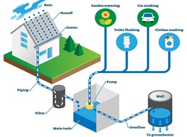
The collection, treatment, and storage of rain or stormwater for the purpose of re-use, such as irrigation or flushing. The impermeable catchment area defines storage tank capacity.
Green Roofs
Constructed roofs that can support vegetation, absorb rainwater, improve air quality, and prolong the life-cycle costs by protecting the underlying roof system.

Wet Ponds
A wet pond is a facility that accumulates run-off, provides permanent (or temporary – dry pond) storage, and treats the stormwater via sedimentation.

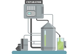
Grit Separator
Drainage devices that are effective at removing smaller particles from stormwater, such as phosphorous, nitrogen, and hydrocarbons.
Urban Development
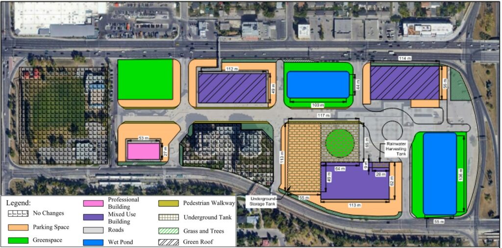
This project is unique and innovative because this is primarily a water & transit orientated redevelopment being done in a brownfield site. Using water to reshape redevelopment is mainly done in greenfield sites; therefore, we are going outside the lines with these innovative approaches. The proposed design aims to redevelop the existing site into a modernized hub for work, living, and leisure. Special consideration will be taken into the placement of new infrastructure, such that it will integrate along the city’s existing piping and transit networks. Overall, the proposed design will be accessible, aesthetically appealing, and inclusive to all. Using density parameters, we calculated how many people we can reside and provide jobs for with our proposed layout in the site.
| Total Area (ha) | Population | Living Units | Jobs |
|---|---|---|---|
| 15.35 | 2310 | 1540 | 770 |
Meet Our Team Members


Details About Our Design
Drainage and Watershed Management
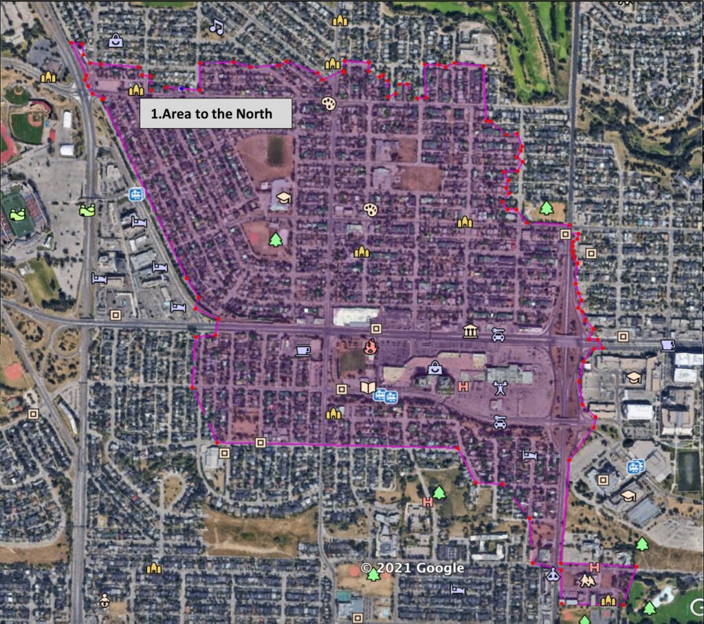
Drainage and watershed management is how effectively we can store, convey, and drain run-off, mainly the area of concern north of the site. The criteria we looked at included volume reduction and peak flow reduction. To determine the volume of water that the stormwater management devices would be required to handle, the unit area release rate method was used. This method takes into account the area of the site as a whole, as well as the permeability of surfaces within the boundaries to produce an estimate of the required on-site runoff storage for a 1:100 year storm event. In addition to the volume of water produced on site, our design considered a larger area outside of the site boundaries that has runoff directed towards a trap-low north of the site. This volume was also included in the storage calculations as one of the main intentions of our design was to mitigate the flooding that would occur at the trap-low.
TOTAL VOLUME OF RUNOFF
To conduct the UARR calculations, the site was split into several separate catchment areas. The table below shows the areas that were measured for values of imperviousness, total area, and runoff generated. The north catchment stretches north and south of the site and is where a majority of the flow is coming to our site. The other catchments are contained within the site, and were used to determine on-site runoff volumes at key locations for the pipe network.
| UARR (L/s/ha) | Location | Area (m2) | % Impervious | Required Storage (m3/ha) | Total Storage (m3) | Sum (m3) |
|---|---|---|---|---|---|---|
| 16 | Catchment 1 | 1,590,372 | 0.75 | 300 | 47,720 | |
| 16 | Catchment 2 | 11,872 | 0.5 | 230 | 280 | |
| 16 | Catchment 3 | 7,006 | 0.6 | 260 | 180 | 50,410 |
| 16 | Catchment 4 | 29,732 | 0.73 | 300 | 880 | |
| 16 | Catchment 5 | 52,939 | 0.59 | 260 | 1,380 |
Through the use of the UARR method, we were able to determine the volume of storage our site would need in order to handle the runoff generated by a 1:100-year storm event. This value was used to determine how to break up where storage occurs, which allowed a general pipe network layout to be produced.
PIPING DESIGN
Utilizing the dual drainage system, water is conveyed through streets and sewers depending on the type of storm. Minor systems convey water for regular storms of up to a 1:2 year or 1:5 year storm events, to avoid ponding on the street. Major systems convey water for major storm events of up to 1:100 year storm events, and temporary ponding is expected during these events. The figure below highlights how stormwater is carried and conveyed through multiple means within the site.
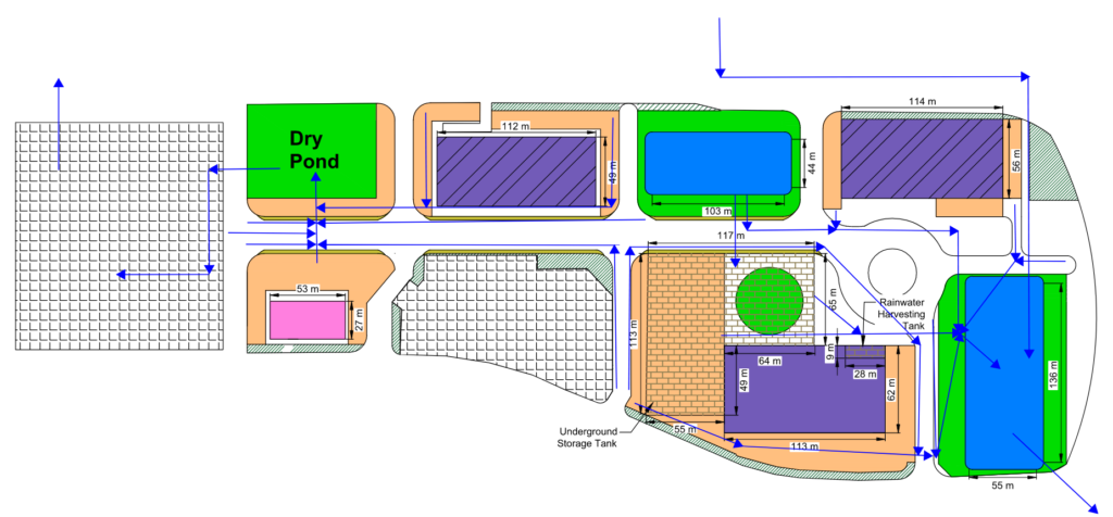
The pipe system for the site begins at the North and extends through the site and out into an existing stormwater line located southeast of wet pond 2. The pipe network was designed to accommodate peak flow conditions of a 1:100 year storm event, and to convey the water into the site for both storage and drainage of runoff after the event. The pipe system is split into four main components, listed as lines 1 through 4. These lines extend from the trap-low and connect wet ponds 1 and 2, as well as a storage tank. The two critical lines are shown below.
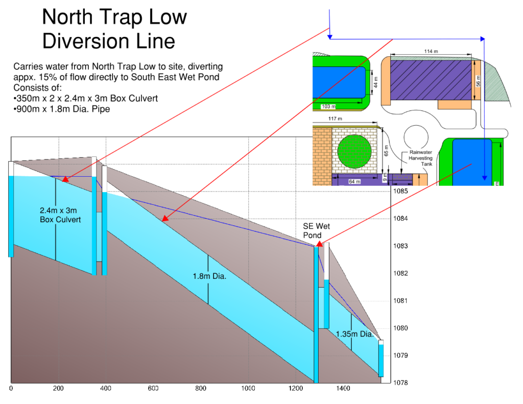
Line 1 stretches from the trap-low to wet pond 2, splitting off from the larger box culvert before reaching the north end of the site. This line carries 20% of the flow from the trap-low into wet pond 2 for storage.
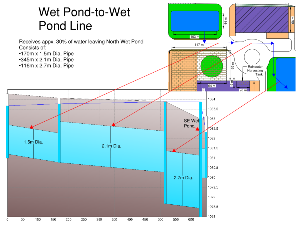
Line 2 begins at the flow split and travels south, carrying the remaining 80% of the flow into wet pond 1. Line 2 continues through this pond and connects it to wet pond 2, helping to keep the storage more equal between the ponds, as well as to collect and convey surface runoff produced on site through manholes along the line.
Flood Risk Analysis and Mitigation
Since flooding is the main concern at the site, we had to incorporate various source control systems to effectively manage flooding by safely draining, storing, treating, and re-using stormwater run-off. Our site layout mitigates the flooding area north of the site using both overland and underground conveyance of stormwater into a wet pond immediately adjacent to this flood zone with stormwater tank following. The impact of failure is also greatly reduced as the design has a significant amount of overland conveyance in the form of roads to redirect potential flood water from any overflowing storm system and ultimately off the site.
WET POND DESIGN
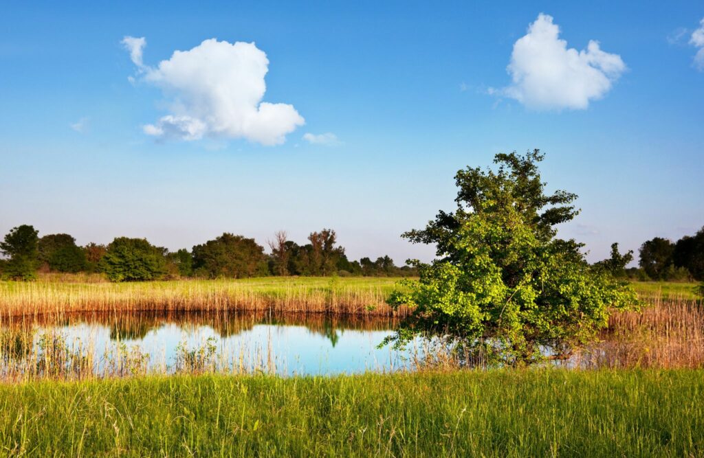
Wet ponds are catchment basins used to collect stormwater, providing storage, and reducing the risk of downstream flooding, erosion, and contamination. Wet ponds also enhance water quality by removing pollutants through sedimentation. During rainfall events, additional temporary storage is provided above the permanent level, this is known as the High Water Level (HWL). After the rainstorm, the water level gradually recedes back to its original elevation, the Normal Water Level (NWL).
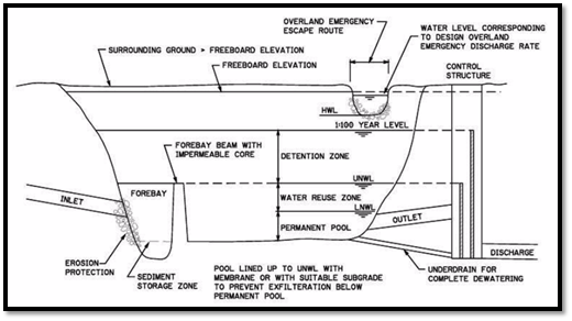
The volume of water at the NWL is the permanent storage capacity of the wet pond. Volumes that pass the NWL as a result of storm events begin to drain through the outlet of the wet pond. This temporary volume above the NWL and between the HWL is known as the active storage volume. Wet pond storage capacity’s and active storage volumes are shown in the table below.
| Wet Pond | Storage Capacity (m3) | Active Storage (m3) |
|---|---|---|
| North | 4,320 | 6,340 |
| Southeast | 9,810 | 11,350 |
STORAGE TANK DESIGN
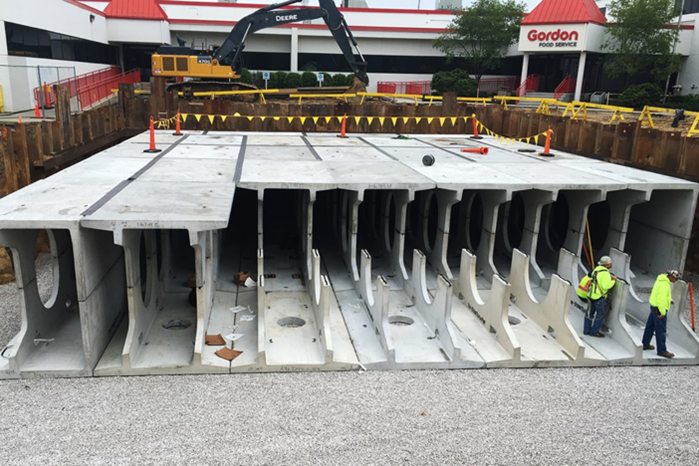
The North and Southeast wet ponds do not have the storage capacity to support runoff collected from the North trap low. To solve this problem, the underground storage tank will act as relief storage for the two wet ponds during the storm event and just like the two ponds, discharge the stored runoff at the tie-in point. After every storm event, the tank is intended to be emptied out completely by a pump to ensure it can be used again for the next storm event.
The pipe network to the tank is designed so the North wet pond outlet drains into the tank. Then, once the tank reaches its storage capacity, runoff is discharged by a pump into the Southeast wet pond. Therefore, the required tank size is the difference between the amount sent to the North wet pond and its corresponding allowable storage. The table below shows the required tank storage calculated to be 31,850 m³ which means the tank is responsible for 83.4% of the runoff going into the North wet pond from the trap low. Due to the large quantity required, a quote for a custom tank to a manufacturer is the most viable option to fulfill design requirements.
| Allowable Storage (m3) | Amount Sent to the Wet Pond (m3) | Required Tank Storage (m3) | |
| North Wet Pond | 6,340 | 38,190 | 31,850 |
| Southeast Wet Pond | 11,350 | 9,530 |
Sustainable Water Use
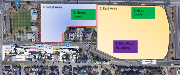
In this design, the south mixed-use building integrates a rainwater harvesting system by collecting water in its roof. Rainwater harvesting systems capture and re-use rainwater, reducing the volume of stormwater run-off from the site. This results in reduced pollutant loadings, reduced erosion, and an improvement in overall watershed management. The re-use of rainwater also reduces the demand on potable water supply within the water management system. In this system, rainwater is collected from a roof area of an impermeable surface, and then it drains into a storm sewer system that stores the water for re-use such as irrigation use and/or toilet flushing.
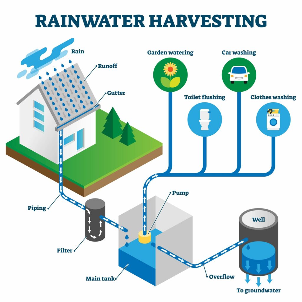
Rainwater harvesting systems are part of the innovative green building movement, and are becoming a viable technology in an urban setting. This is because:
- Rainwater is a relatively clean and absolutely free source of water
- It promotes self-sufficiency and helps conserve water
- It uses simple technologies that are inexpensive and easy to maintain
- It is one of the most convenient system as it provides water at the point of consumption.
The rainwater harvesting tank size is determined by the average annual rainfall in Calgary and the roof catchment area of the building that will utilize the harvested rain. The required storage tank is 90 m3 as shown in the table below.
| Roof Catchment Area | 7,006 | m2 |
| Average Annual Rainfall in Calgary | 324.4 | mm |
| Total Runoff from Roof | 2,286.7 | m3/year |
| Required Tank Volume | 90 | m3 |
Water Sensitive Urban Development
Water sensitive urban design (WSUD) uses better urban planning and design to reuse stormwater, stopping it from reaching our waterways by mimicking the natural water cycle. This method of urban design focuses on two areas of stormwater, quality and quantity. It aims to improve the ability to capture, treat and productively use stormwater before it gets into the natural bodies of water. One of the design aspects from WSUD that we have at our site are green roofs. Green roofs are contained areas of vegetation, such as trees, shrubs, or grasses, planted on top of a building to help manage stormwater through various hydrologic processes. Converting a traditionally impervious surface to a medium that will absorb and retain a large amount of precipitation will result in decreased stress on sewer systems at peak flow periods. This is done through the vegetation on green roofs capturing rainwater, encouraging evapotranspiration and therefore, reducing the volume of stormwater entering receiving water bodies. . There are two basic types of green roofs: intensive and extensive. An extensive green roof is a light system of drainage and filtering components and a thin layer of soil mix, whereas an intensive systems allows for deeper soils to accommodate a greater diversity of plants and can be used for recreational space.
Green roofs are part of climate-proof construction that help solve environmental problems by bringing nature back to the city in key ways. If properly designed, constructed and maintained, green roofs can:
- Reduced runoff volumes which will also improve water quality
- Moderation of Urban Heat Island Effect
- Improved air quality
- Increased habitat promoting biodiversity
- Reduced energy consumption in some climates
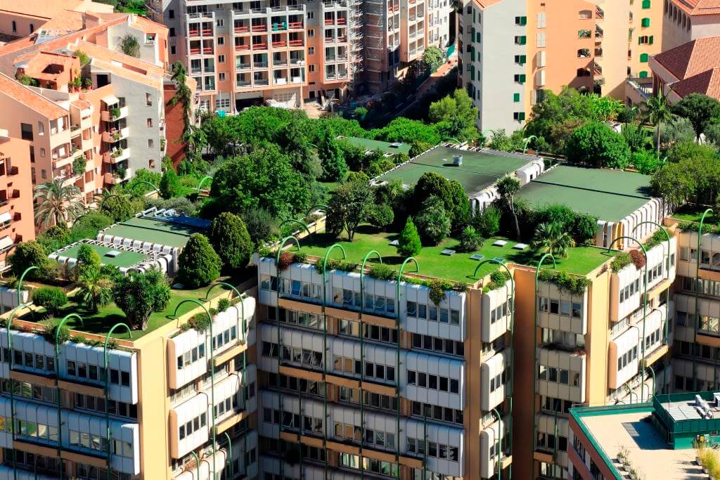
We decided to choose an intensive roof for our design because it requires the deepest soil, therefore accommodating all types of plantings including large shrubs and trees. From a storm water’s perspective, this is crucial because the deep soil acts as a reservoir to store maximum water. Additionally, intensive roofs create a park-like setting because they have more structural integrity and allow for pedestrian traffic. Therefore, the redevelopment of this site is done with water sensitive urban design methods.
PCSWMM Model
We validated our design using PCSWMM, which is an advanced modelling software for stormwater, wastewater, watershed, and water distribution systems. This software was chosen because it is widely used in industry and it successfully models the main aspects of our design including stormwater systems and LID (low impact development) areas. To mitigate the flooding in the north, several storage units and LID practices have been modelled to reduce the overall runoff from the site.

To model the performance of the stormwater system, the east half of the site was split into the following 5 sub-catchment areas.
- Sub-catchment “Surrounding Community” represents the large area in the north which includes the critical flood zone. This area collects the water to be mitigated by the design, and it contains the trap low from which water enters the stormwater pipe system.
- Sub-catchment “NWP” makes up the north wet pond and its surrounding absorbent landscape.
- Sub-catchment “East Green Roof” makes up the green roof on the northeast mixed-use building.
- Sub-catchment “On-Site Catchment” makes up roads, green spaces, the south commercial building. Due to the increased green space throughout this space, this area has both pervious and impervious areas.
- Sub-catchment “SEWP” makes up the southeast wet pond and its surrounding absorbent area.
| Catchment Name | Area (ha) | Flow Length (m) | Slope % | Impervious (%) |
|---|---|---|---|---|
| Surrounding Community | 159.01 | 1,206.99 | 0.5 | 75 |
| North Wet Pond (NWP) | 4.88 | 220.84 | 0.5 | 25 |
| East Green Roof | 0.64 | 80 | 0.5 | 50 |
| On-Site Catchment | 22.21 | 230.08 | 0.5 | 25 |
| Southeast Wet Pond (SEWP) | 6.65 | 257.83 | 0.5 | 25 |
The southeast wet pond is within the “SEWP” sub-catchment, and it is the last storage unit before water is released downstream. It collects and stores water from all points in the site. Water from all other catchments drain into this area to be stored in the wet pond and its then released into the existing tie-in within the City’s storm sewer system. The goal of this model is to minimize runoff released into this tie-in.
| Storage Unit | Average Volume (x1000m3) | Average Percent Full (%) | Max Volume (x1000m3) | Max Percent Full (%) | Maximum Outflow (m3/s) |
|---|---|---|---|---|---|
| North Trap Low (SU1) | 0.15 | 15 | 0.96 | 100 | 39.02 |
| North Wet Pond (SU2) | 2.66 | 41 | 6.14 | 95 | 22.15 |
| Storage Tank (SU3) | 15.54 | 42 | 12.5 | 100 | 6.42 |
| Southeast Wet Pond (SU4) | 5.19 | 49 | 30.34 | 96 | 0.67 |
The above table shows the full summary of performance results for the four storages involved in our simulation (North Trap Low, North Wet Pond, Storage Tank, and Southeast Wet Pond). The North Trap Low storage is calculated using the allowable storage depth of 0.5m as per industry advisor instruction. The Wet Ponds and Storage tank volumes are determined based on the physical geometry as per the 2011 Stormwater Management and Design Manual.
Conclusion & Recommendation
The project was successful as the conceptual stormwater management system design was able to address all the site’s concerns:
- Drainage and Watershed Management was improved by developing a comprehensive piping network that better facilitated the collection, conveyance, and release of excess stormwater.
- Flooding Risk was minimized by providing storage basins in the form of wet ponds and an underground storage tank as the primary and most effective mitigation strategy.
- Sustainable Water Use was implemented via a rainwater harvesting system, that re-uses excess stormwater as a renewable commodity for toilet flushing and irrigation.
- Water Sensitive Urban Development was incorporated into the site through the design of green roofs, to not only provide amenity and aesthetic benefits but also aid in volume and energy use reduction.
In validating the conceptual stormwater management system, extensive engineering calculations and industry backed procedures were utilized. A PCSWMM model was developed with a City of Calgary water balance sheet to simulate the effects of run-off against historic precipitation data. The model resulted in a 0% continuity error – signifying that all stormwater produced was accounted for and safely released at an acceptable value.
The conceptual stormwater management design is feasible in that host of benefits it provides and the risks it mitigates far outweigh the costs of construction. The consequences of flooding, contamination, and erosion are quantified and effectively minimized. Urban development is greatly improved by providing increased transit accessibility, as well as the additional housing, jobs, and recreational opportunities created. Overall, the redevelopment this area provides a sustainable community site with more effective land use, restored biodiversity, and improved stormwater management conditions.
Partners and Mentors
We would like to extend their appreciation to Mr. Bert van Duin for his guidance and technical expertise that were vital in the completion of this project. Special thanks to Dr. Kerry Black for her knowledge and continual words of encouragement to the team. Further recognition is given to Brad Larson and Dave Mair from the City of Calgary, and Rachelle Dillon from O2 Planning + Design, for their expert advice and contributions to the project.
Our Photo Gallery
