Project Category: Geomatics
Join our presentation
About our project
Levelling is an ancient branch of surveying that seeks to determine the elevations of points on the earth’s surface. Geomatics engineers are particularly interested in orthometric heights, or elevations that use the geoid as a vertical datum. Orthometric heights were traditionally determined by spirit levelling. Over the past four decades, however, Global Navigation Satellite System (GNSS) levelling has gradually replaced spirit levelling. Geomatics engineers and surveyors cannot utilize the GNSS levelling framework unless they have access to a reliable and accurate digital local geoid model. Our project rectifies this issue by designing a spatial database that facilitates the investigation, comparison, selection, interpolation, and manipulation of datasets to compute a local geoid model for obtaining elevations from GNSS levelling measurements in Alberta.
Meet our team members

Eugene Lok
Eugene Lok is a 4th year Geomatics Engineering student. He was the technical lead for Digital Geodesy and handled the computational aspects of the project, such as calculations, data validation, and accuracy assessments. Eugene would like to eventually leverage his programming knowledge to help develop innovations in Geographic Information Systems (GIS) and the Internet-of-Things (IoT).

Faith Nayko
Faith Nayko is a final year Geomatics Engineering student and will also complete her Bachelor of Commerce degree next year. Throughout her time at the Schulich School of Engineering, Faith did a four-month internship in GIS analysis and a twelve-month internship in transportation engineering. Faith was the project manager for this Digital Geodesy project and was responsible for scheduling/monitoring work packages and writing the project reports.
Brendan Mathews
Brendan Mathews is in his final year of his BSc in Geomatics Engineering this semester. He is very eager to jump into the workforce as soon as possible, his passions laying deep in software and cartography. Brendan was the communications lead for the Digital Geodesy project, having been responsible for organizing weekly meetings, creating maps and visual deliverables, and arranging the student testing plan to quality check the entire project.
Details about our design
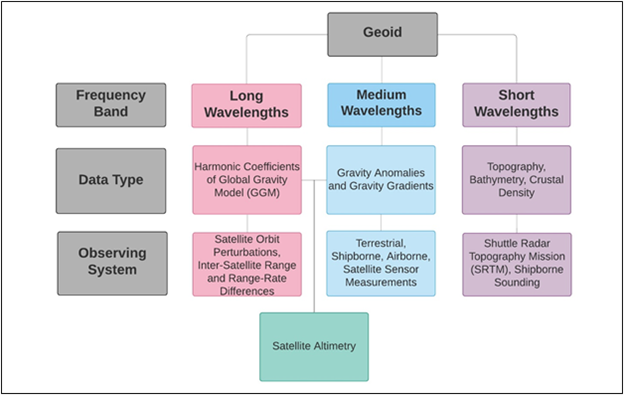
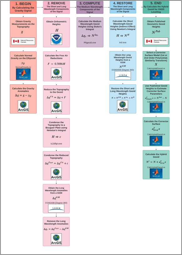
The Remove-Compute Restore (RCR) method is a common algorithm for calculating the local gravimetric geoid using terrestrial gravity data. The local gravimetric geoid is calculated using gravity anomalies, or the differences between gravity observed on the topography and the theoretical gravity on the ellipsoidal surface. In the RCR method, the long and short wavelengths are first removed from the gravity anomalies, which are reduced from the topography to the geoid. The remaining medium wavelength anomalies are used to calculate the medium-wavelength geoid height. Finally, the short and long wavelength components are restored, and the three geoid height components are added together. Further datum discrepancies are modelled using a corrector surface to obtain the hybrid geoid, which is the model used for GNSS levelling.
E. Rangelova. ENGO 423. Lecture Notes, Title: “Chapter 8: Determination of the Earth’s Figure and Gravity Field.” Department of Geomatics Engineering, University of Calgary, Calgary, Alberta, Canada, Winter 2020.
Geoid models for geomatics engineers and surveyors to use in GNSS levelling projects are available in different capacities online. For instance, GGMs are available online through services such as the International Centre for Global Earth Models (ICGEM). ICGEM is service coordinated by the International Association of Geodesy (IAG) to collects and archives existing global gravity models (GGMs). It also provides a public web interface for downloading these models. Despite this interface, the downloaded data is not directly compatible with standard GIS software and the user must perform several conversion steps, which are not necessarily intuitive. Furthermore, these GGMs only reflect the long wavelength component of the geoid. Geodesists who create GGMs can only provide coefficients up a maximum degree and order (i.e., spectral resolution) which corresponds to the spatial resolution of the gravimetric data that is used to produce the GGM, because wavelengths less than twice the average spacing of the local geoid being computed are aliased. CGG2013 is the most recent local geoid model published by Natural Resources Canada.
Provincial governments may also calculate, publish, and maintain local geoid models that contain all three wavelength bands within their own jurisdictions. CGG2013 is the most recent local geoid model published by Natural Resources Canada. There are several additional challenges with public gravimetric geoid models such as CGG2013 that geomatics engineers and surveyors must overcome to utilize them for GNSS levelling.
- Users must where to go online to access the CGG2013 model.
- Users must have software compatible with the model’s file format.
- Users must ensure that the horizontal coordinate system and reference ellipsoid used for CGG2013 match those being used for their GNSS levelling projects.
These steps for obtaining geoid heights from a public geoid model are convoluted, non-intuitive, and frustrating, especially for geomatics engineers and surveyors who specialize in levelling but are not necessarily familiar or comfortable with troubleshooting the GIS processes and conversions described above.
An additional challenge with GGMs and CGG2013 is that they are both gravimetric geoids. However, GNSS levelling projects require a hybrid geoid which closely matches results from GNSS levelling methods. Additionally, modern hybrid geoid models such as CGVD2013 are not publicly available, and older hybrid geoid models such as CGVD1928 are static, and do not move with terrain. Thus, publicly available models are not fully suitable for GNSS levelling projects.
Our project overcomes all the challenges above by creating a database containing a ready-to-use local geoid model using the remove-compute-restore method in a format that is compatible with GIS software for geomatics engineers and surveyors in Alberta. It also contains additional files and functions for users to calculate the geoid themselves, along with a user manual with metadata for all datasets provide in the user manual, documentation for the MATLAB functions, and comprehensive instructions for geoid computation.
WHAT MAKES OUR DESIGN INNOVATIVE
The project consists of two primary components. The first component consists of a local geoid model that geomatics engineers and surveyors can utilize for GNSS levelling projects, and the input datasets that geomatics engineering students will use to calculate the local geoid via the RCR method. The second component is the database system to store the datasets described above, as well as any supplemental files or functions that are required to extract data or calculate the local geoid using the RCR method.
WHAT MAKES OUR DESIGN SOLUTION EFFECTIVE
The database system is intuitive and as easy-to-use as possible because it is intended to be used as an educational tool and as an easy way for Geomatics engineers and surveyors to extract orthometric heights for GNSS levelling projects. In addition, the database system’s usability is increased by the provision of a user manual to provide information about the database system, its objectives, and datasets that it contains. First, the user manual must provide metadata for each dataset that the database contains so that students, engineers, or surveyors can easily understand the properties of each dataset and the information that each represents.
HOW WE VALIDATED OUR DESIGN SOLUTION
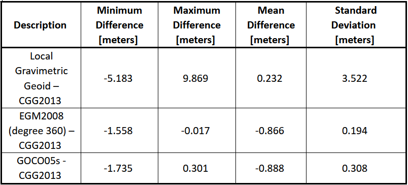
The hybrid geoid could not be compared to the geometric geoid at the CBN stations because there were not enough stations within the study area to sample some out from the corrector surface calculations for an accuracy assessment. The accuracy of the hybrid geoid also could not be assessed by comparing it to CGVD2013 because it is not available online. Therefore, the quality of the local gravimetric geoid was assessed instead by comparing it to CGG2013. The maximum absolute difference between CGG2013 and the local gravimetric geoid calculated by the project team is nearly ten meters. Despite the extreme values, however, the local gravimetric geoid calculated by the project team shows is more accurate with respect to CGG2013, compared to the other GGMs shown in the table below. Nevertheless, the local gravimetric geoid calculated by the project team fulfills the acceptance criterion for being as close as possible to the geometric geoid while maintaining a one arcminute spatial resolution because it is close to CGG2013.
Our database model was validated by implementing a student testing plan for students enrolled in the ENGO 423 class. The team designed 3 laboratory assignments in which students calculated components of the local gravimetric geoid, hybrid geoid, and relevant statistics using selected datasets from our database, with help from our user manual. Feedback from students was collected and analyzed to improve the datasets’ ease of use, clarity of the user manual, and robustness of the database.
FEASIBILITY OF OUR DESIGN SOLUTION
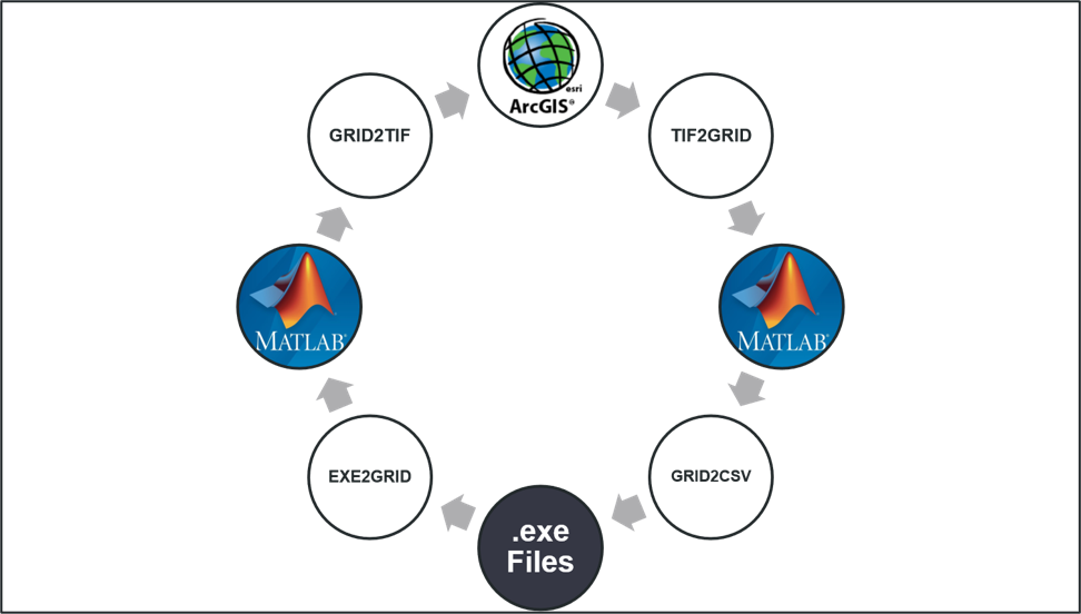
Along with the local gravimetric geoid and hybrid geoid models, the project team developed a database system that users can utilize to calculate the local gravimetric geoid and hybrid geoid. Database users can also extract the local gravimetric geoid and hybrid geoid produced by the project team to obtain orthometric heights for GNSS levelling projects. This system consisted of the ArcGIS geodatabase, which stored the GeoTIFF files provided by the project team, and MATLAB functions to make the files compatible between ArcGIS and the executable files that are required to calculate the local geoid model. The database system is accompanied by a user manual, which provides metadata for all datasets in the database, documentation for all MATLAB functions, documentation for all ArcGIS tasks, and instructions. There are detailed instructions that users can use to completely reproduce every dataset. This system is most useful for future ENGO 423 students and instructors who would use t his database to gain familiarity with geodetic computation and for teaching purposes related to geodesy.
However, we were unable to test the database on industry users, who have different needs and skill levels than ENGO 423 students. Therefore, testing on this user group is an opportunity for future work. There is also an opportunity to test the usefulness of the database for calculating the hybrid geoid, not just the gravimetric geoid, in ENGO 423 labs since we were unable to do that this semester, but this is relatively minor. Further work can also be done to improve the accuracy of our local geoid model, because extreme values exist which were caused by poor interpolation of point gravity values used to calculate gravity anomaly, a component of the local geoid. Another opportunity for future work is to develop new software so the local geoid model can be calculated for the entire province of Alberta, rather than a limited view of southern Alberta. Not only would the model then be valuable for more projects and users, but there would be more CBN stations so some could be sampled out to perform an accuracy assessment of the hybrid geoid, which was not possible with the limited spatial extent.
Partners and mentors
We would like to thank Dr. Elena Rangelova, who provided us with assistance and valuable feedback from the very beginning of the project.
Our photo gallery
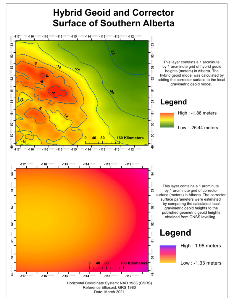
Map of our Hybrid Geoid and Corrector Surface Models 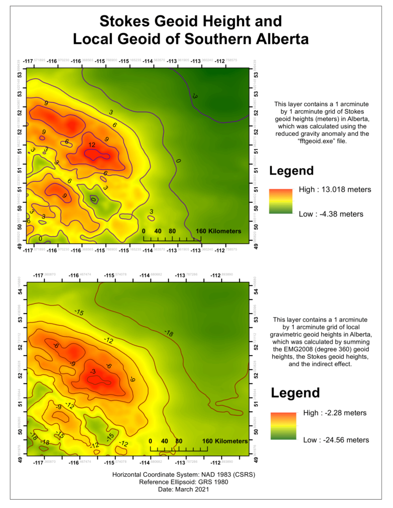
Map of the Stokes Geoid Height and our Local Gravimetric Geoid