Project Category: Geomatics
Join our presentation
About our project
Our project started in September of 2020 in the midst of the Covid-19 pandemic with the goal of creating a geomatics solution for Covid-19 exposure notifications or contact tracing.
We determined a platform that uses volunteered geographic information (VGI) could reduce the strain on agencies that perform time and resource intensive manual contact tracing. VGI is data uploaded by private citizens in a collaborative way that creates a useful map or geographic dataset. It’s free and widely available!
We also found that citizens had a distrust of exposure notification applications because they collected user location or Bluetooth data, so we resolved to create a platform that would work without collecting any user data at all.
What we came up with was Covid-19 Maps, where citizens can report infectious periods that occurred in public locations and other citizens can view these cases. This gives citizens the ability to perform contact tracing and to view possible exposures to a certain extent.
The web-app is designed to be used on a smartphone, but a desktop version is also available. Please visit the site through the link below or visit covid-19maps.ca on your smartphone. A video demonstration is also linked.
Meet our team members
Mitchell Brown
Torri Kondics
Katharine Mairin Rockliff
Zoe Walsh
Details about our design
HOW OUR DESIGN ADDRESSES PRACTICAL ISSUES
The Covid-19 global pandemic is a grave issue and one that the entire world has been struggling to manage since March 2020. Manual contact tracing and exposure notification apps have been used in attempting to track the spread of Covid-19. Unfortunately, manual contract tracing is time and resource consuming and exposure notification apps are not widely used. During the Fall 2020 wave of rising Covid-19 cases in Alberta, it was not possible for Alberta Health Services (AHS) to keep up with the manual contacting tracing as it was previously being performed, and as the Canadian exposure notifications apps are not used by the majority of the public, these were also unable to aid AHS. We aimed to create a web-app design that can improve upon contact tracing and increase voluntary public participation in the government provided exposure notification apps. Ultimately, our web-app is designed to reduce the burden of manual contact tracing on health services and to make greater amounts of Covid-19 community information available to the public quickly and easily.
WHAT MAKES OUR DESIGN INNOVATIVE
The Covid-19 contact tracing web-app we have developed utilizes Volunteered Geographic Information (VGI). This means the public has the ability to voluntarily upload their information if they test positive for Covid-19 to aid in community contact tracing efforts. Essentially, when an individual finds out that they have Covid-19, they would go to our web page and upload the date(s), time(s), and location(s) where they were in public while possibly contagious. Other members of the public can then look at the map and see if they were in a public place where transmission of the disease could possibly have occurred. This design is innovative because, while VGI has often been used in emergency disaster situations, we have not seen VGI being utilized to address an ongoing public health crisis. In addition, contact tracing has never been performed in such a way as to allow citizens such a great degree of control without oversight by a public health agency. The web-app does rely on assuming that citizens will take great care to protect their community, providing and using data in an informed and responsible manner – citizen science is an integral aspect of the web-app.
WHAT MAKES OUR DESIGN SOLUTION EFFECTIVE
Our web-app’s design solution is highly effective since it improves upon contract tracing methods and better disseminates contact tracing information to reach more of the public. Manual contract tracing being done solely by the AHS is not a realistic solution for tracking the spread of Covid-19 because it requires far too many resources and far too much time to be effective. Additionally, the exposure notification apps put out by Canadian governments do not have a wide enough user base to be effective. The design solution we have created would instead allow the public to become more informed about the spread of Covid-19 in their community, giving them the power to perform some contact tracing for themselves thus reducing the amount of manual work effort needed to conduct contact tracing. Additionally, we performed some research on the citizen science components of the web-app framework to determine if people would utilize the web-app’s design in real life or be more likely to utilize exposure notification apps that had the features of the web-app incorporated into them. The majority of respondents indicated that they would indeed use the web-app in real life and saw themselves as more likely to download an exposure notification app with such features.
HOW WE VALIDATED OUR DESIGN SOLUTION
The design solution was validated through multiple rounds of quality analysis tests performed by the team members as well as by feedback surveys that recruited users unfamiliar with the web-app to perform testing. To initially validate the Beta version of the web-app that was created based off of the project proposal, team members evaluated the app using a quality analysis process where, prior to beginning testing, a document was created to outline how each component of the web-app was expected to work. After performing this quality analysis testing, changes were made to the Beta version of the web-app based on failed testing categories or other testing comments to ensure all expectations were met. After the web-app fully passed the team’s quality analysis inspections, a 20 person test group composed of team member’s friends and family was emailed instructions to perform user feedback testing along with the links to the web-app and to a testing feedback survey form. The results of this survey were reviewed by the team and used to move the web-app from its Beta stage to its Alpha stage.
In the Alpha version of the web-app, additional functionality was incorporated based on the user testing feedback that helped to improve major issues of ineffectiveness or areas lacking clarity. Again, the team members performed quality analysis testing as described above. Once the quality analysis testing had passed, the Alpha version of the web-app was distributed for another round of user feedback testing. We reached out to the Geomatics Engineering community for feedback, along with our friends and family, and received 40 responses in total. This feedback was used to further refine the web-app. Additionally, this round of user testing incorporated questions in citizen science topics in order to validate the design solution as addressing the societal issues identified with exposure notification apps. All final changes made to the web-app were put through final quality analysis testing until everything passed and the web-app design was finalized. We reached out to COVID Alert Canada at the beginning of our project with some questions. The final version was sent to COVID Alert Canada as follow-up to obtain further professional feedback that we look forward to receiving.
FEASIBILITY OF OUR DESIGN SOLUTION
The web-app we have developed to address some of the issues around Covid-19 contact tracing and exposure notifications is extremely feasible. We have developed a fully functioning web-app that better engages the public in a way that allows them to both protect their privacy and to share and use information about Covid-19 cases in their community. The engagement of the public creates crowd-sourced contact tracing, reducing the load on manual methods. As well, our testing feedback indicated that the web-app’s features promoted engagement and gave better value to citizens in such a way that they would be better encouraged to download exposure notification apps, even if they do have to give some personal location information. Our web-app’s features could theoretically be merged with the currently functioning exposure notification apps in Canada, specifically ABTraceTogether for Alberta and COVID Alert for the rest of Canada. It would be extremely feasible for the features we have modelled through our web-app to be incorporated into these existing apps to improve functionality and user engagement, thereby addressing the root of the problem that drove our design solution.
Photo Gallery
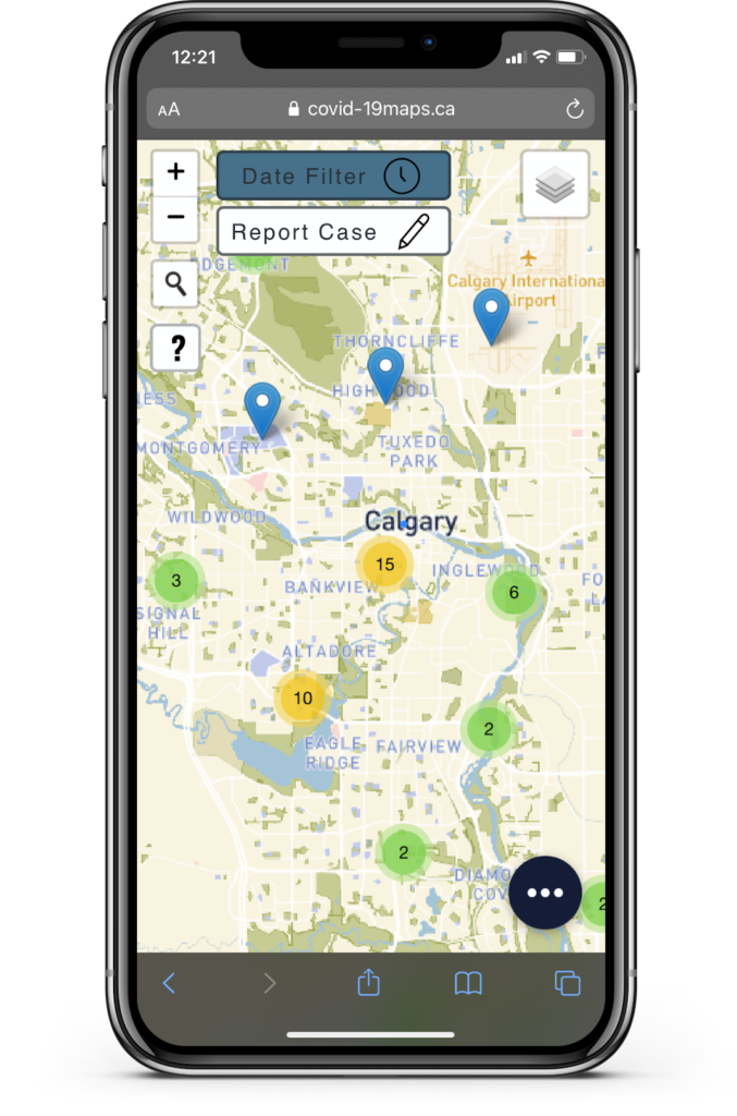
Main map page
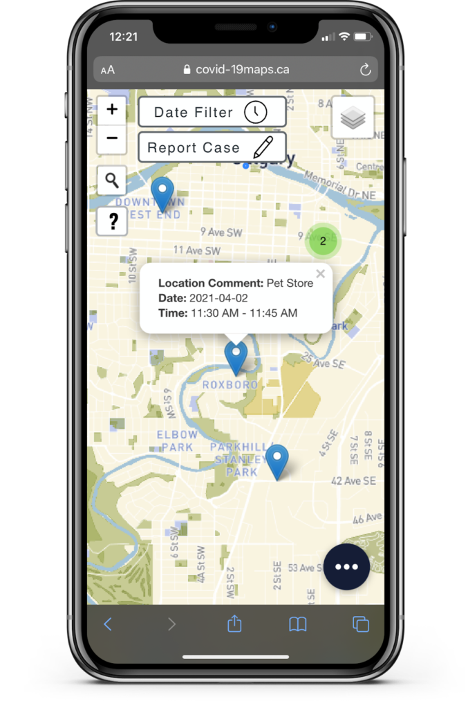
Pin information pop-up
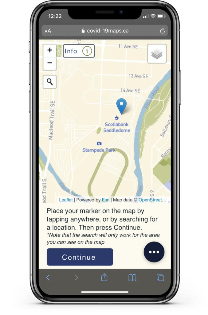
Report case – choose location
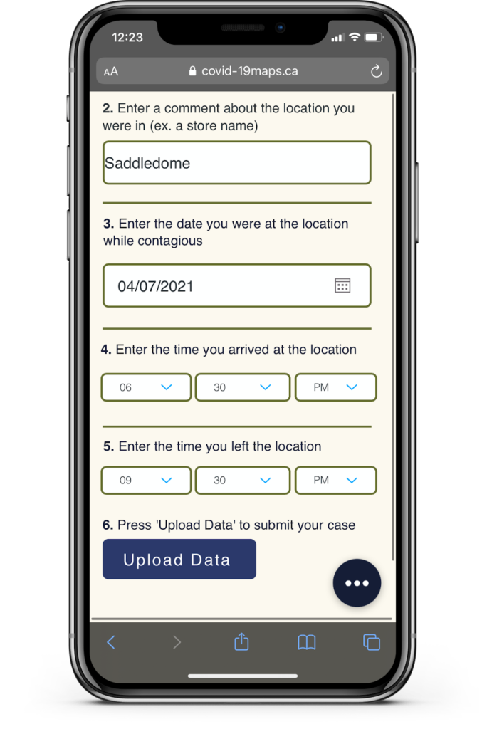
Report case – information
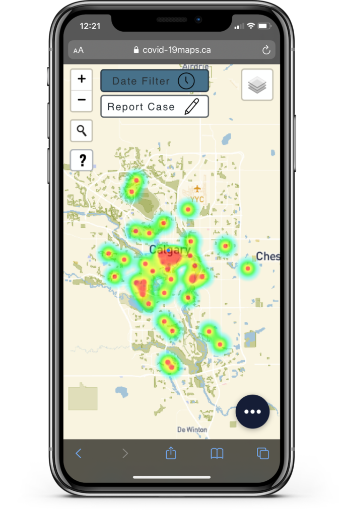
Heat map layer
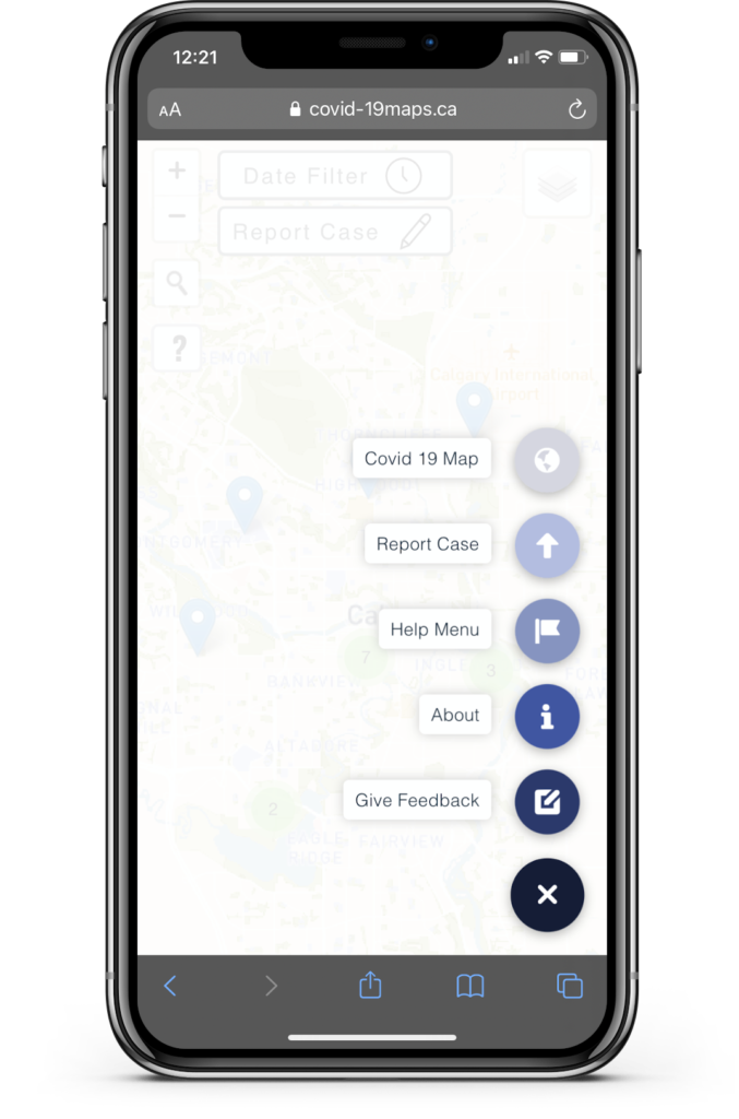
Quick access navigation menu
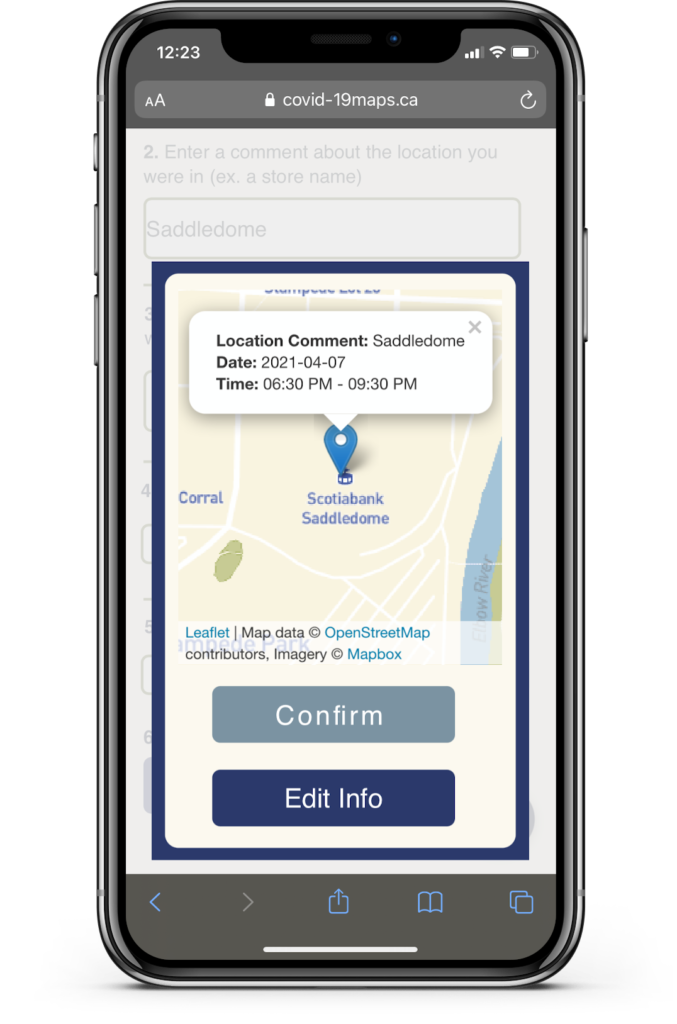
Review case to be reported
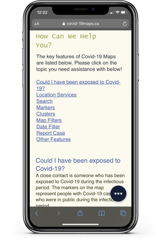
Help menu
Partners and mentors
We want to thank the many people who helped us with this project. First, thank you to our geomatics engineering project advisor, Dr. Yang Gao. Also, thank you to the many individuals who helped give feedback on our solution in its various rounds of testing.
