Project Category: Geomatics
Join our presentation
About our project
Geomatics engineering is a broad discipline and requires a large amount of fieldwork with sophisticated equipment for data acquisition. It is necessary that teaching geomatics engineering incorporate these field work experiences to properly prepare new hires for real work in industry. The COVID-19 pandemic has greatly impacted the availability of and opportunity for learning experiences in the field of geomatics. Yet, there is a clear need by industry to ensure potential new hires, of diverse educational backgrounds, have an acceptable level of knowledge and experience in geomatics related concepts. Industry employers require employees who have relevant knowledge and skills needed to deal with increasing accessibility and usage of Geomatics related technology.
This project is a pilot program created in order to confirm assumptions the team has created and verified with industry professionals regarding the relevancy of geomatics skills in the workplace. In this pilot program an eight day course on the topics of 3D modelling was created and verified with the 8 test users who participated in this pilot program through the online educational platform of thinkific
Meet our team members
Sudam Fernando

Madison Marriot

Tanya Hegmann

Alhassan Natah

Details about our design
HOW OUR DESIGN ADDRESSES PRACTICAL ISSUES
Geomatics technologies are becoming more and more commonplace in industry as as sensors develop to be more cost effective, accurate and accessible. Take the example of the brand new IPad 2020 and the IPhone 12 pro offering the access to a LiDar scanner integrated within the phone itself. These everyday devices offer the use of GPS, IMU and high resolution cameras in order to and we can use this technology to perform basic Geomatics practices and can also be used to teach the necessary skills for these practices without the need for expensive equipment.
Online degrees are slowly becoming more and more accessible and affordable becoming alternatives to standard degree programs due to their affordability, asynchronous learning that allows for individuals with busy life styles to learn specific skills as well as in some cases the industry partnered lessons. Many of these online courses have various courses that are created with industry partnership that offer the users an insight into the real world problems and solutions used by the industry.
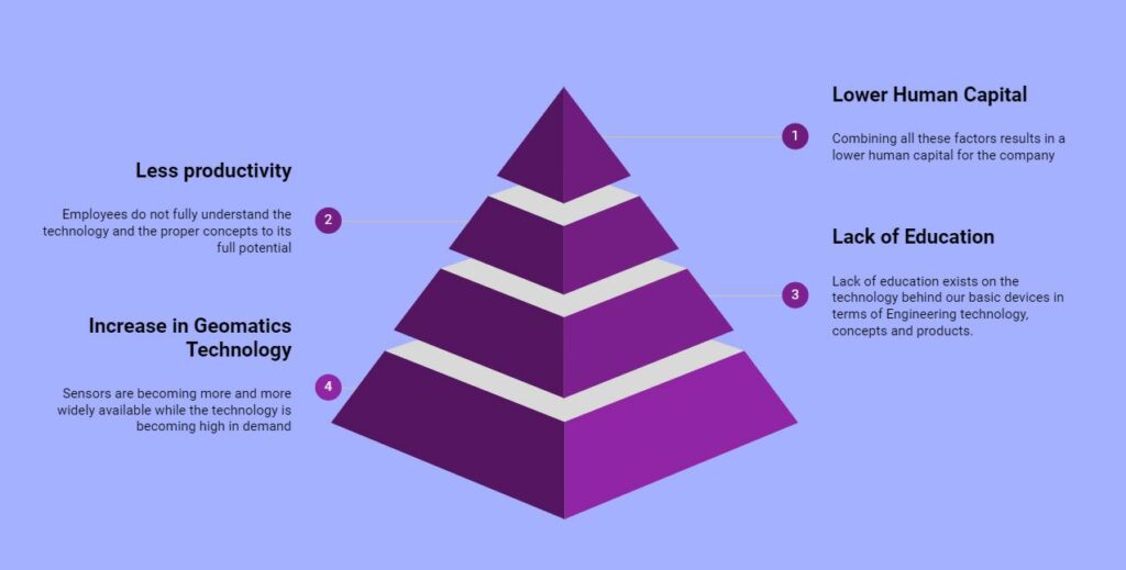
The problem the team took on was that there is in increase in geomatics technology, followed by a lack of educational platforms that allow for the individuals get training and upskill on the topics of geomatics, this can eventually lead to a drop in productivity of users who do not know how to properly use the sensors they are working with which ultimately causes a lower human capital for any company employing these individuals
WHAT MAKES OUR DESIGN INNOVATIVE
With the only proper way of getting proper geomatics education being limited to traditional four year degree or diplomas at technical schools, our solution is designed to tackle the conventional way of acquiring Geomatics knowledge by offering an asynchronous online platform that allows for users to go through different lessons in their own pace. This course is also designed with mind that many users are not able to spend the same time commitment as traditional students, hence only two hours of their day is needed to complete a lesson.
Although Geomatics Engineering is overflowing with expensive and intricate equipment, our solution is designed to be completed with any smart device such as a cellphone or a tablet, and although the new IPad 2020 or IPhone 12 is used for the LiDAR data collection, it is not necessary as data for each day is provided. Although this is simply a pilot program to validate a larger solution, the pilot program was created with the advisory of the industry to confirm the assumptions made by the group and break and better the solution as it progressed forward.
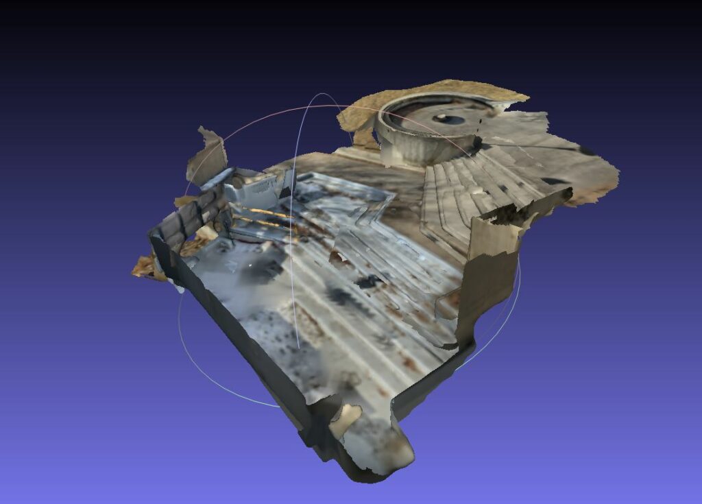
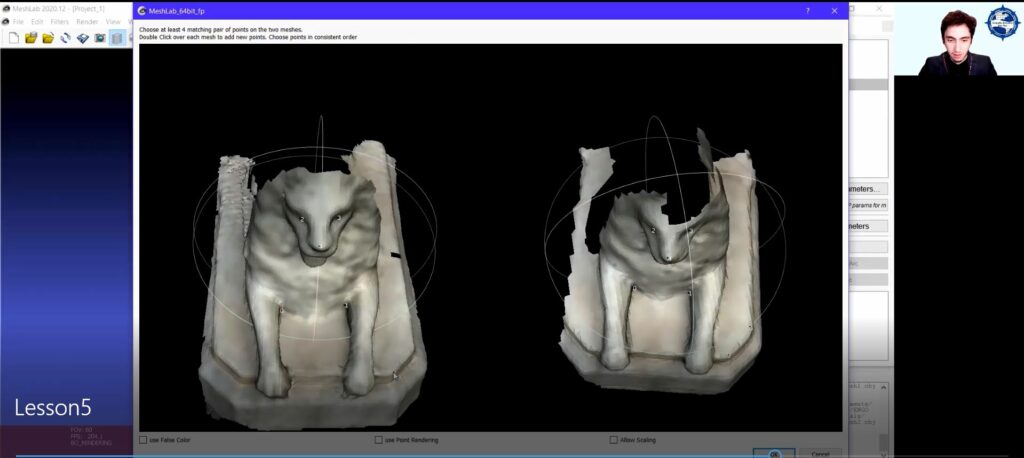
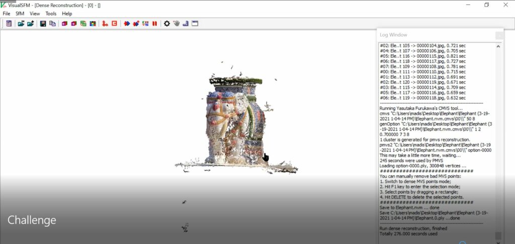
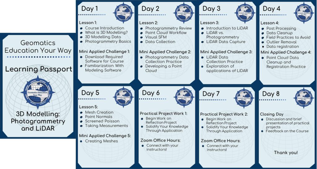
The final topic chosen by the team for the pilot project was 3D Modelling: Photogrammetry and LiDAR. The course contains :
- Five days of Asynchronous lectures followed by mini-applied challenges (small projects)
- Two days of practical project work (large project that ties in everything the user has learned)
- Final day of an asynchronous meeting for presentation of the practical project
The course content can be seen below :
WHAT MAKES OUR DESIGN SOLUTION EFFECTIVE
This free eight day course offers the users a glimpse into the technology behind one of the most time efficient and revolutionary topics in geomatics without the need for any expensive hardware for data collection or software for the data processing. This solution is designed in order to take the user from the data collection process of photogrammetry and LiDAR in the field to the data processing to create a final 3D model in the office in order to give the user a full glimpse into the field to finish cycle that takes place in the real world.
The solution is also designed to improve the skills of the user on the topics covered in each days lesson through applied challenges. Once the lecture portion of the day is finished, the user participates in a challenge that allows them to apply the skills learned through the class content. On the sixth day of the course, users are introduced to a practical project that allows them to apply all the skills they have learned over the past five days into one final project that takes them from the lessons they learned in day one to the last day.
HOW WE VALIDATED OUR DESIGN SOLUTION
In order to validate our solution, the team as well as the geomatics engineering department advertised the course for users to sign up if their interest was piqued. In the span of a week, the course had 26 individuals who were interested in taking the course. Although this number dropped to eight users when the course started, these test users were to take part in the lessons created by the team and offer feedback on each of the lessons as well as the whole course itself at the end of the eight day period. These users who completed the whole course were then given certificates showcasing their success in the course.
FEASIBILITY OF OUR DESIGN SOLUTION
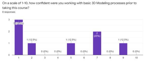
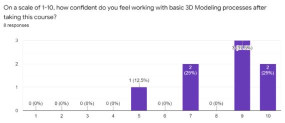
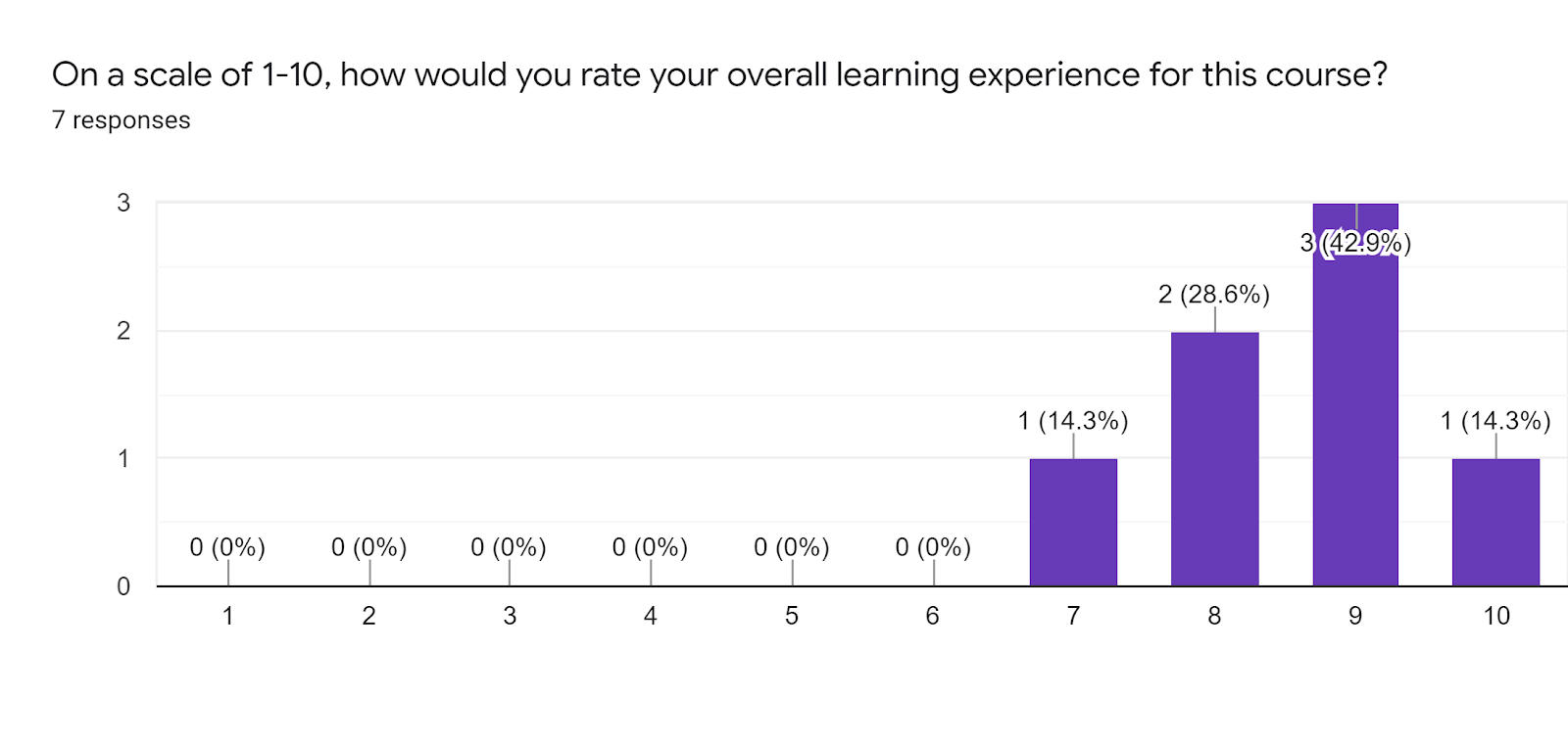
The feasibility of the design solution of this project was taken from the feedback given by the eight test users on their experience on the course as well how well the course boosted their skills. These were the feedback taken from the users :
User Average Confidence in 3D Modelling Before Course: 4.13
User Average Confidence in 3D Modelling Before Course: 8.25
100 % of the users found the course to be helpful in onboarding situations
Other Popular course ideas that users would be interested in taking : 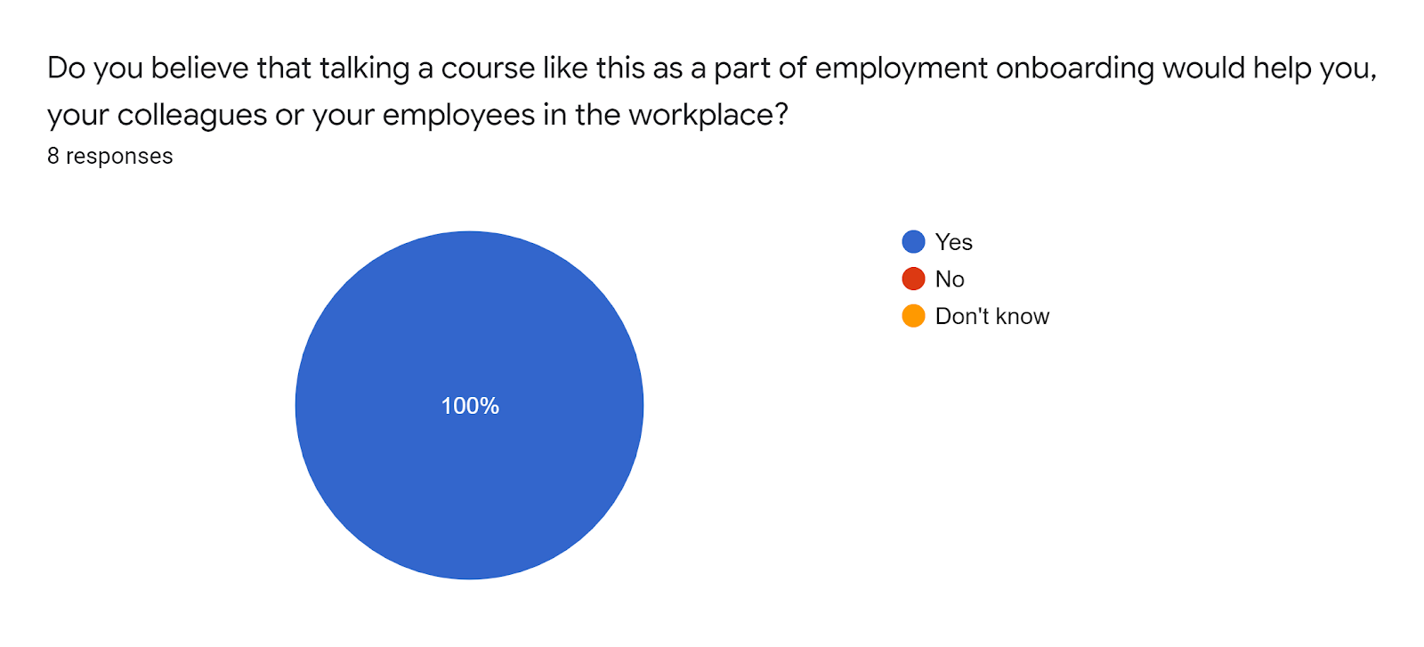

87.5 % of the users found the asynchronous found the asynchronous style of learning beneficial :

Feedback on the overall experience of the course
“I think the course went into sufficient detail for what was outlined and gave the students the knowledge needed to understand 3D modelling projects and data capture options.”
“Great course! Would definitely be interested in taking additional courses in the future!”
“great short course to fill me on on a bunch of holes from field too finish within my career as a surveyor transitioning more into the mapping side of surveying. thanks!”
Looking at the feedback on the overall experience as well as how the course has helped users boost their skills we can confidently say that the solution is feasible and more courses with the same style of teaching could be created in the future with a larger scope
Partners and mentors
We want to thank the many people who helped us with this project. Our project advisor Dr. Alex Bruton who guided the team through the creation of this design with much patience and brilliant insight as well as Dr. Elena Rangelova who offered much needed feedback on the course content as the solution progressed as well as Jonathan Neufeld and Natasha Spokes who offered invaluable insight into the industry needs in order to break and better our solution.